Friday, March 1, 2013
11:39 A.M.
 |
| Weezy approves of the weather. |
Well everybody, it has been awhile. I had a midterm today, and I have midterms Monday and Thursday next week. It never ends! However, I have a brief break between classes and I thought I’d post a blog instead of eat some lunch. I’m not hungry.
Although we don’t get super humid like the East Coast, we can get relatively humid on winter days when some subtropical moisture gets entrained in the jet stream and is directed toward us. Many of you (especially those of you who live by rivers) are familiar with the infamous “Pineapple Express.” During a Pineapple Express event, an ‘atmospheric river’ of moisture from the subtropics (often originating near Hawaii, hence the name) is directed northward into our area and often brings incredible amounts of rain. Some might say it rains cats and dogs, but I prefer to say that it rains pineapples. The picture below is the only thing I could find on the internet that resembled the raining of said pineapples… I guess I’ll have to buy a video camera to catch the raining of pineapples next time the Pineapple Express hits the west coast.

To summarize, Pineapple Express events involve obscenely high amounts of rainfall and very mild/humid air. We are seeing some pretty mild and humid air right now, but the rainfall over us is relatively sparse. So what’s happening?
Although our warmest wintertime temperatures come during Pineapple Express events, we can still get quite warm when the Express is to the north of us. And that’s precisely what is happening now. We are getting the warm temperatures from the south side of the baroclinic band (which is a fancy way to describe a semi-stationary front) since the southern part of a storm in the northern hemisphere is where the warmest air resides, as air is pulled from the tropics into the low.
 |
| 11:30 am PST Fri 01 Mar 2013 – UW West Coast NWS GOES-West 4km Infrared Satellite |
This isn’t a very strong Pineapple Express… maybe you could call it a Pineapple Trolley. Nevertheless, so how the moisture coming into the area originates from the subtropics near Hawaii? That’s where our warm air is coming from, even though the precipitation is above us. The moisture train itself is modeled beautifully by the UW’s WRF model. Check out the picture below from the model initialization this morning.
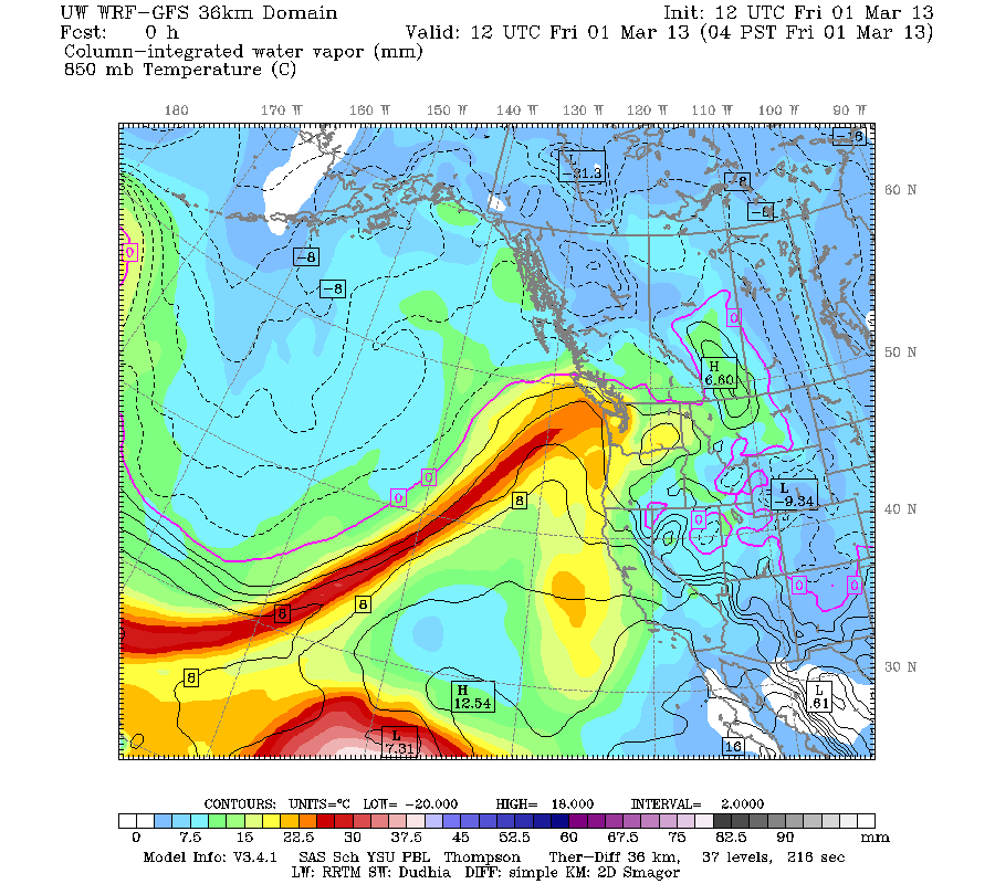 |
| Valid 04:00 am PST Fri, 01 Mar 2013: UW 12z WRF-GFS: 36km Column Integrated Water Vapor |
You can really see why these streams of moisture originating from the subtropics and extending into the mid-latitudes are called atmospheric rivers. Moisture simply flows along this front, which is often stationary. The stationary factor is one of the reasons why these Pineapple express events cause flooding… they drop lots of rain over the Pacific Northwest (especially the mountains) and just don’t let up. I remember the huge Pineapple Express event from November 5-7, 2006, in which an atmospheric river stalled over our area for nearly two days. Many rainfall records were broken, and Mt. Rainier was particularly hard hit, as they got 18 inches of rain in 36 hours. Simply incredible.
I could watch this all day.
Ok, time to go to physics and learn about magnets!
Peace,
Charlie

1 Comment
lol I did not know that the video recorder had audio too… heheh