The Moisture Train Of Doom

Thursday, November 12, 2015

9:53 am

Everybody talks about atmospheric rivers. Atmospheric river here, atmospheric river there. And while the “atmospheric river” term is certainly useful and is used in scientific literature, it also comes across as a bit of a euphemism. It sounds so nice and tranquil, like a stream flowing through the heavens, when in reality, it could lead to a stream flowing through your living room.

I’ve thought of different names to call these pesky atmospheric rivers, including “the atmospheric super-soaker,” “Noah’s nemesis,” and my favorite, “the moisture train of doom.” Here’s what the National Weather Service had to say about this atmospheric river during last night’s forecast discussion. And yes, they always write in all caps.

A WET FLOOD-PRODUCING ATMOSPHERIC RIVER EVENT WILL BE SETTING UP ON THU AND LASTING UNTIL SAT MORNING. THE PATTERN IS BEING BEING AIDED BY THE DEVELOPMENT OF A STRONG AND CONSOLIDATED UPPER JET STREAM OVER THE NE PAC…TO THE SOUTH OF A VERY DEEP 965 MB LOW CENTERED NEAR KODIAK ISLAND ALASKA. WATER VAPOR IMAGERY SHOWS THE JET TAPPING INTO A TROPICAL MOISTURE SOURCE ALL THE WAY BACK NEAR GUAM.

They didn’t bold that last part, but I did, because I think it’s extraordinary. Guam is nearly 5,700 miles away from us. Don’t believe me? Take a look at images for yourself!

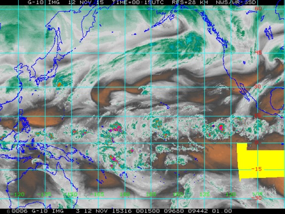
4:15 pm PST, 11/11/2015. Credit: NOAA Western Regional Headquarters

This satellite image above was taken yesterday (it was the
most recent this view had), but the image below shows the moisture train of
doom right over our area right now.

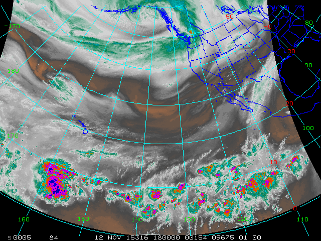
10:00 am PST, 11/12/2015. Credit: NOAA Western Regional Headquarters

By now, you are probably wondering if we truly are doomed. Honestly, we probably aren’t in the long run, but…

In fact, some of you could have a very bad time, particularly those who have experienced bad times with relentless atmospheric fire hoses in the past.

Over the 72-hour period from 4 a.m. this morning to 4 a.m. Sunday morning, much of the Western Washington lowlands could pick up 3-4 inches of rain. However, as is often the case with these events, the mountains are going to take the brunt of the rain. Areas in the Olympics and Cascades north of Snoqualmie Pass should pick at least 5-10 inches, with many places picking up over 15 inches! I wouldn’t be surprised if some of the very highest, most favorable spots in the Olympics picked up over 20 inches.

Valid 04:00 am PST, Sun 15 Nov 2015 – 72hr Fcst
Credit: UW Atmospheric Sciences
Snow levels will be high, but they won’t be through the stratosphere (well, they never are, but you get the point). Because this river has a more westerly component to it, temperatures will be cooler, and snow levels will rise to 7-8 thousand feet tonight. During some of our truly devastating atmospheric rivers, the moisture has had more subtropical origins, often originating from Hawaii and causing snow levels to skyrocket to 10-11000 feet, meaning that everywhere but the tops of Mt. Adams and Mt. Rainier experience rain. November 6, 2006 was one of those downpours, as was the “Great Coastal Gale” of December 3, 2007.
This will help mitigate some of our flood worries, but because this isn’t the first atmospheric river event of the season, I suspect that flooding will be worse overall with this system than the one on Halloween. Additionally, we have a little bit of snow in the mountains, and the rain could melt this snow away, further contributing to flooding in the area. A large snowpack actually helps mitigate flooding because it absorbs the rain and prevents it from draining into rivers, but a low snowpack often absorbs some rain at first and then all melts at once, releasing additional water and doing so in a short period of time.
I don’t see this atmospheric river causing any record crests on rivers, but it could cause a couple rivers to reach major flooding stage, particularly those on the Olympics (the Skokomish is particularly susceptible). I think it will cause more flooding than our previous atmospheric river just two weeks ago though. Look at the difference in the “column-integrated water vapor,” which is a measure of how much water vapor exists in a column of the atmosphere extending from the surface. 
Valid 05:00 am PDT, Sat 31 Oct 2015 – 36hr Fcst
Credit: UW Atmospheric Sciences
Valid 01:00 pm PST, Thu 12 Nov 2015 – 9hr Fcst
Credit: UW Atmospheric Sciences
As you can see, our atmospheric fire hose is much more robust than it was two weeks ago.
Of course, we’ve got a whole bunch of other things to worry about as well.
Credit: Seattle NWS Office
We’ve got wind advisories for the Puget Sound region, and high wind warnings for the Northern Interior and Northern Coast. We also have a high surf advisory for 19-22 foot seas off the coast due to strong winds over a very long fetch of water, and we even have some winter weather advisories for the North Cascades for 3-11 inches of snow before snow levels rise to 5,000 feet this evening. I’m not too concerned about the strength of the winds… most places in Western Washington won’t see any gusts higher than 50 (except for the North Interior), and even those places with high wind warnings should see their gusts below 65, save a couple exposed areas like the aptly-named Destruction Island. The main concern with these winds will be their duration, as we should be pretty gusty until Friday night.
It will be an active stretch for us! Weather geeks like me
love this kind of weather, and I hope you like it too! If you live on a
floodplain, be prepared for a possible flood, particularly if you are situated
on the Olympics. They will get clobbered.
Charlie

You may also like

Leave a Reply

Your email address will not be published.