Friday, November 13, 2015
 |
| Credit: PRISM Group and Oregon Climate Service. Retrieved from Reddit (yup!) |
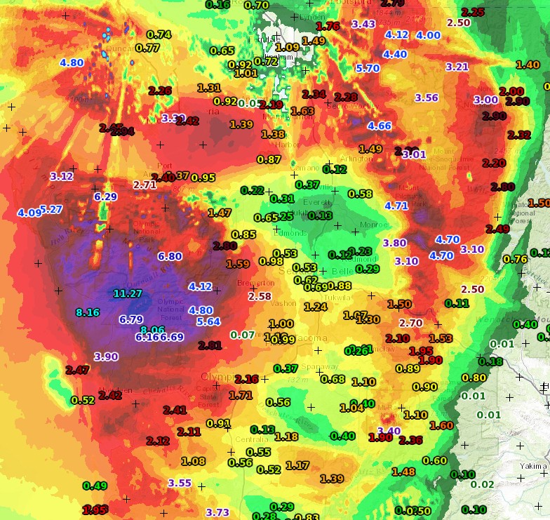 |
| 24-hour precipitation ending ~1 pm, 11/13/2015. Credit: |
One site near Lake Quinalt on the Olympic Peninsula (specifically, USCRN site QTCW1) has experienced over 11 inches of rain in the last 24 hours. Meanwhile, folks near Everett have experienced just over a tenth of an inch of rain. In other words, some spots on the Olympics have gotten 100 times as much rain as places 80 miles to the ENE. And the sole reason for this is the Olympic mountains. It’s truly mind boggling. A tenth of an inch of rain is enough to make sidewalks wet, and maybe create a puddle or two. Eleven inches will cause major flooding, and already has on the Skokomish River.
Seattle has also been firmly under the influence of this rain shadow. Many places in Seattle have only gotten half an inch of rain or so, while places near Sea-Tac have picked up twice that. The rainshadow was particularly present last night, as this WeatherOn radar image shows.
 |
| Credit: WeatherOn with WeatherCaster |
This leads us to the age-old Western Washington forecasting dilemma: how do you explain that some locations will get major flooding, while still telling people that they’ll likely stay dry?
From what I’ve noticed, nobody seems to talk about rainshadows beforehand. I didn’t mention it at all in my previous blog post (even when I knew it was going to happen), the Seattle National Weather Service office didn’t explicitly mention it in any of their forecast discussions, the news stations didn’t write about it on their website (with the exception of Q13 Fox, who inferred it on their site but never actually used the word “rainshadow” or any derivations of it). I didn’t watch the news segments, so it is likely that the weathermen explained the rain shadowing effect when they pulled up animations of the radar, but fewer people watch the news these days and instead get their news from smart phones and other portable electronic devices, so this is something that should have been highlighted online. Cliff Mass blogged about it, but not during his forecast before the storm… only after the rainshadow became apparent on radar. Cliff doesn’t have any obligation to forecast for the public – he goes out of his way to write a blog because he loves sharing his knowledge of weather and climate (among other things) with the public, but the news stations and NWS do.
If we don’t explicitly explain to people in the Puget Sound lowlands that they will get significantly less rain due to the rainshadowing effects of the Olympics, we have not done our job as forecasters. I’m not blaming anybody here, especially because I did the exact same thing. But it is a wake-up call.
Charlie


