Tuesday, December 1, 2015
10:15 pm
Hey everybody. Sorry for being absent for over a week. It’s been a crazy past eight days here in Charlie-town, and when you add that to the extraordinarily boring weather we’ve had, you nearly almost always end up with a blog drought. Thankfully, the drought ends now, as the first storm of many has just exited the region, and another is entering right now.
But before we talk about our active week ahead, I’d like to touch on some of the weather that occurred over the past couple days. Since Thanksgiving, we’ve been victims of what I (and many other meteorologists) like to call “fake cold.” This “fake cold” I’m talking about is cold air that is concentrated right at the surface, while air aloft is much warmer. This is known as an “inversion,” and is called such because the temperature increases with altitude. In ‘normal’ situations, the temperature decreases with altitude in the troposphere (the lowest level of the atmosphere, where almost all our weather occurs).
To see the difference between real cold and fake cold, let’s take a look at some of the temperature soundings from the profiler over by Sand Point.
 |
| Credit: UW Atmospheric Sciences |
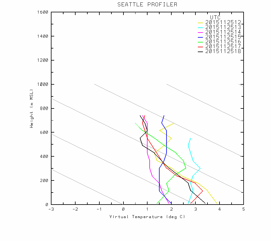
This group of soundings (one every hour from 4 am to 10 am Wednesday) shows that the air is pretty cold throughout the atmosphere. Yes, the atmosphere is more stable than usual and there are a couple inversions, but there is not one giant inversion separating cold air below from warm air above.
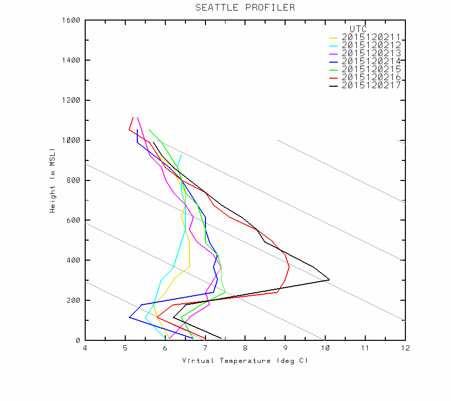
Now, look at that same group of soundings on Sunday.
 |
| Credit: UW Atmospheric Sciences |
Now THAT’S an inversion! At 12 UTC, the inversion starts at the surface, and for the others, the inversion starts around 100 meters above sea level. We go from near freezing at the surface to 9 degrees C by 900 meters, and I think it’s safe to assume that we’ve hit 10 degrees C by 1 kilometer. In Fahrenheit, that’s an 18 degree temperature change. This means that the top of Tiger Mountain near Issaquah was likely near 50 degrees from this period, while many places in Seattle were around freezing, and many places in the Cascade foothills and South Sound dipped into the low 20s. Freezing levels were up near 9,000 feet, which is higher than they’ve been all November – including during our atmospheric river events.
Inversions often trap moisture and pollutants near the surface, so we had deteriorating air quality throughout the latter half of the week and dense fog near the surface, particularly near bodies of water or in valleys/sheltered areas. Some of this fog was “freezing fog,” meaning the droplets froze on contact with a surface and made for very slippery and dangerous conditions on the roads, particularly for the morning commute.
 |
| Credit: UW Atmospheric Sciences |
This morning, we still have some of our inversion left, but it is much shallower and will continue to weaken throughout the week. Inversions are pretty common, but it’s not often when Camp Muir up at 10,110 feet is warmer than Olympia!
This Week
 |
| Credit: National Center for Environmental Prediction |
The United States’ flagship global model, the GFS (Global Forecast System) is painting a very wet next two weeks for us. The above picture shows the total accumulated precipitation over the entire period the model is run (384 hours, or 16 days). The chart above has pretty low resolution (something tells me Mt. Rainier will get more rain than Seattle!), and once you get past 10 days, it’s almost impossible to forecast individual storms, but it is still great for getting a general idea of the weather over the next two weeks. The GFS is showing 20-25 inches of precipitation over Vancouver Island, and only a little less than that over the Olympics and Northern Washington/Southern BC Cascades. The rain even extends to Cape Mendocino in California, and the Sierras look to get some much needed snowfall.
Over the weekend, we had a stubborn ridge of high pressure directing storms far north into the Alaskan Panhandle, but now that ridge has collapsed, and the Pacific Northwest is once again in the direct path of some powerful, wet Pacific storms. Even though the effects of El Niño become more pronounced after the New Year, I’m surprised by how different our weather has been from what was forecast by climate models. We’ve been wetter and cooler than normal, while Southern California has been warmer and drier than normal. We’ve got the strongest El Niño on record brewing in the tropical Pacific, but you wouldn’t know it if you lived on the West Coast.
Several ski resorts around the area have opened with limited operations, but we should get gobs of snow in the mountains over the next couple weeks, and I suspect that most resorts throughout the Pacific Northwest will be open to at least some degree by mid-December. Many places in the Cascades picked up 6-12 inches of snow last night, and they will pick up another 6-12 inches over the next 72 hours. Even though snow levels will generally be above Snoqualmie Pass, there is enough of that residual low-level “fake cold” in Eastern Washington that will be flowing east through the pass to locally lower the snow level to the surface, so be prepared for snow, sleet, or freezing rain at the Summit and points east tonight before switching over to rain tomorrow. Stevens Pass could see a foot of snow before the precipitation changes to liquid Thursday afternoon.
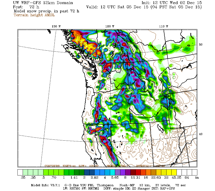 |
| Valid 04:00 am PST, Sat 05 Dec 2015 – 72hr Fcst Credit: UW Atmospheric Sciences |
Even more snow falls over the next 72 hours! Massive amounts for Southern British Columbia. The passes should mainly see rain or a mix because the cold air will have been scoured out, but snow levels may lower again next week.
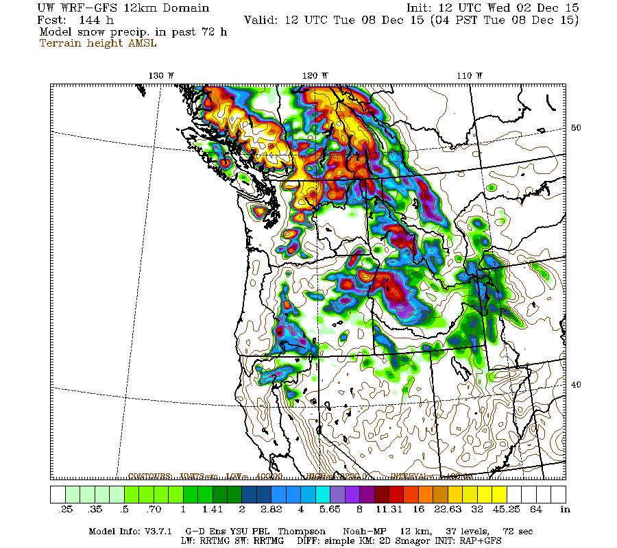 |
| Valid 04:00 am PST, Tue 08 Dec 2015 – 144hr Fcst Credit: UW Atmospheric Sciences |
None of these systems look particularly strong, but it will
be an active period. I like to think of stormy periods in terms of famous
boxers from the 60s and 70s. Right now, we are in a Muhammad Ali pattern with lots
of powerful, rapid-fire storms (as opposed to a Joe Frazier pattern, where we
would have a single massive left-hooking storm from the southwest that could knock
out power to millions with a single punch). I’ll keep you posted!
Thanks for reading,
Charlie

