
I’m a big George Carlin fan, and one of my favorite routines is his comparison of baseball vs football. The thesis of his routine is how baseball is lighthearted and fun, while football is war and nothing less. One example he gives is how a football game will proceed no matter the weather, while a little drizzle will end a baseball game. So when I saw this picture from Husky Stadium last Saturday evening as storms were passing overhead, I knew that Puget Sound was under siege by Mother Nature.
I blame Larry Scott for this. #PurpleReign pic.twitter.com/aHLEhA2ubv
— Joe Lambert (@joelambert206) September 8, 2019
Indeed, Puget Sound was treated to one of the most brilliant lightning displays on record Saturday night with approximately 2,200 strikes recorded between 6 pm and 11 pm. Not to be outdone, the Portland metro area saw massive urban flooding and an EF-0 tornado Sunday evening. Even Monday was pretty crazy – I thought I could forgo my jacket and “thread the needle” between thunderstorms while walking downtown Monday evening, but I ended up paying the price for my gamble!
Lightning
The last dramatic lightning storm I remember personally experiencing in the Pacific Northwest occurred on Friday, August 9, 2013. With that storm, an upper-level trough over Northern California/Southern Oregon directed warm, moist southerly flow into the area, creating very unstable conditions. Upslope flow along the Cascade crest provided the lift to tap into this instability, and storms formed over the Cascade crest and drifted into the Western Washington lowlands under SSE flow aloft. A far more intense thunderfest occurred on May 4, 2017, with 2,500 strikes, damaging winds, and golfball-sized hail, but somehow Portland escaped relatively unscathed through all the mayhem.
While it’s hard to define a “classic” lightning setup for the Pacific Northwest since lightning is so rare here to begin with, our most recent storm may just be it. To get powerful, long-lasting thunderstorms, you need three things: lots of instability (also known as Convective Available Potential Energy, or CAPE), a lifting mechanism that allows air parcels to rise and tap into this CAPE, and enough wind shear to keep the rain-filled downdraft of the thunderstorm from choking off the warm, moist updraft feeding it. But in the Pacific Northwest, you generally need a fourth component – easterly upper-level flow to steer thunderstorms that initiate over the Cascades back into the Puget Sound lowlands. It’s pretty rare to get the magic combination of lift, instability, shear, and easterly upper-level flow all at the same time, but we did on Saturday night, and the results were spectacular.
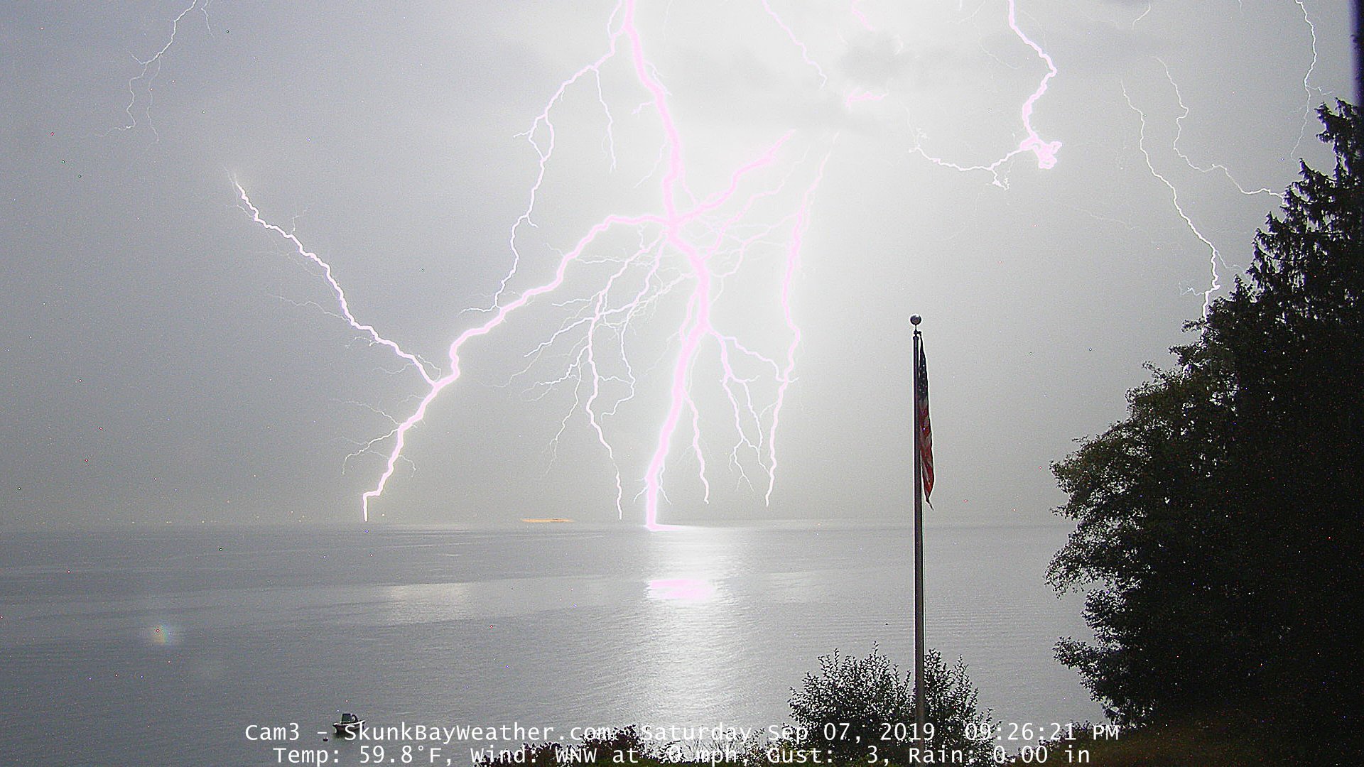
Credit: Greg Johnson of skunkbayweather.com
Let’s walk through the evolution of the upper-level pattern with this storm frame-by-frame. All frames below are courtesy of the University of Washington WRF-GFS model.
At 5 am, we have the calm before the storm. A ridge extends north from the Great Basin into the BC Rockies, but a sharp trough looms offshore.

As this sharp trough approaches, the upper-level flow turns more southerly, pumping warm, moist air into low and mid-levels and increasing CAPE.

By 5pm, the trough axis has moved ashore and flow is directly from the south.

Convection initiates over the Cascades due to both upslope winds from diurnal heating and “dynamic lift” ahead of the trough itself, as troughs are associated with large-scale lift in the atmosphere. This lift occurs in response to the divergence of winds aloft, which subsequently lowers the surface pressure and causes convergence at the surface (since air moves from high to low pressure). The below schematic illustrates how troughs are associated with large-scale lift.

The trough continues to move inland Saturday night, and by Sunday morning, the trough has passed east of the Cascades, bringing our thunderfest to an end.


The new GOES-17 satellite captured some awesome images of thunderstorms exploding Saturday afternoon and evening. These thunderstorms initially formed over the Cascades but subsequently drifted into the Puget Sound lowlands from the SSE. The brighter colors denote cold temperatures (and thus, high cloud tops). These thunderstorms reached heights of 35,000 to 40,000 feet – most of our thunderstorms only reach 20,000 feet!
A satellite loop you wouldn’t normally associate with our area. This is one GOES-17 view of the explosive development of t-storms over the region tonight. This is an infrared loop measuring temperature. Cloud tops reached nearly -65 celsius (over 35,000 feet in height). #wawx pic.twitter.com/pGeRxsERV2
— NWS Seattle (@NWSSeattle) September 8, 2019
Taller thunderstorms tend to have much more lightning, and these didn’t disappoint. The National Lightning Detection Network measured approximately 2,200 cloud-to-ground lightning strikes over Western Washington from 6 pm to 11 pm. The lightning was most heavily concentrated along a line extending NNW from the Southern Washington Cascades to the San Juans. My parents live on the southern tip of Whidbey Island (which is completely covered in red!), and they told me they had never seen such frequent lightning for such an extended period of time.

Credit: University of Washington
Portland Tornado/Flooding
The main show was over by midnight as this sharp-trough moved inland and another weaker, upper-level trough began to move onshore. But this weaker trough brought some surprisingly strong thunderstorms to Western Washington and Oregon Sunday afternoon, bringing urban flooding and even an EF-0 tornado to the northwest Portland metro area.
The below radar image is something folks in Tornado Alley are intimately familiar with, but it may be foreign to many Pacific Northwesterners. It measures the velocities of precipitation relative to the radar -green is approaching, red is departing – and accomplishes this by making use of the doppler effect (where the frequency of a sound/light/etc. wave increases as its source approaches, and vise versa). Meteorologists use these to look for localized areas of circulation that could correspond to a mesocyclone and/or tornado, and these are denoted by small, red/green couplets. Note the red/green couplet a few miles NNE of Rock Creek – this shows the location of the EF-0 tornado, and it prompted a tornado warning from the NWS before there were any reports of a funnel cloud/tornado.


This twister briefly tracked across the Plumper Pumpkin Patch & Tree Farm and caused some light damage.

Retrieved from Portland NWS Twitter Feed
Pics from Jim Kessinger of tornado damage tonight at Plumpers Pumpkin Patch on Old Cornelius Pass Rd in NW Portland. @nwsportland @kgwnews you can even see a circular pattern in the damage. pic.twitter.com/ww3SJ7KrDR
— Matt Zaffino (@Zaffino) September 9, 2019
Sunday night’s thunderstorms moved extremely slowly and dropped tremendous amounts of rain over certain neighborhoods in a very short period of time. Tanasbourne was absolutely clobbered, receiving over two inches of rain in just a few hours. Meanwhile, places just a half mile away ended up with less than half an inch over the course of the entire day.

Credit: Traci Roberts

Credit: Traci Roberts
Looking forward, we’ll see cool, unsettled weather on Monday with a chance of thunderstorms across the metro area in the afternoon/evening. These storms should be weaker than the ones we saw last Sunday and much weaker than those on Saturday, but with such saturated soils, any rain that does fall will likely just run off into the roads, so I wouldn’t rule out some ponding on the roadways with particularly heavy showers/t-storms. Yet another strong cold front will push through Tuesday with more showers on Wednesday, but we should finally some calmer weather Thursday-Saturday before rain returns Sunday.
As a reminder, you can follow me on Facebook or Twitter for quick weather tidbits and updates in the event that I can’t find time to write an entire blog. I’m trying to up my weather social media game a bit, so expect to see some more material on those pages!
Thanks for reading, and have a great week!
Charlie
