Running out the door to head to my energy trading shift, but thought I’d post a quick update regarding the historic arctic blast and our accompanying lowland snow chances before then. Hope to have more tomorrow when there’s a bit more time! Arctic blast: Our extended/extremely strong arctic blast is still on tap, and […]
Brutal Cold To End 2021, White Christmas Possible
The Pacific Northwest has seen tons of mountain snow over the past 10 days. Since December 9, Snoqualmie Pass has seen approximately 8 feet of snow, and all of the major Cascade ski resorts, from Mt. Baker in the North Cascades to Mt. Bachelor in Central Oregon, opened for limited operations last week. I haven’t […]
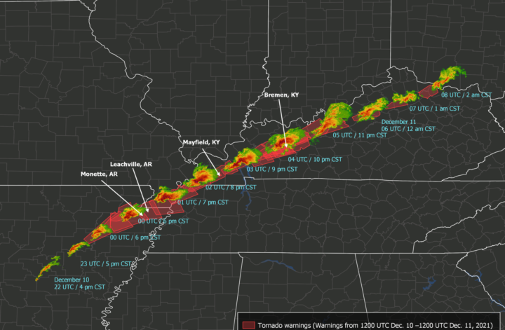
Record-Setting Tornado Outbreak Devastates South and Midwest
Last night, a rare, catastrophic tornado outbreak occurred over portions of the Southern and Midwestern US. As of Saturday afternoon, 34 people were confirmed dead, with an estimated 75-100 deaths across Missouri, Illinois, Tennessee, and Kentucky and potentially 50-70 deaths in Mayfield, Kentucky alone. Most deaths were due to a series of tornadoes – or […]
My Skagit River Flooding Adventure, The Week’s Forecast, and Mountain Snow In The Extended
When I was younger, my mom and I would always explore Seattle and look for the biggest puddles to (safely!) drive through after heavy rain events. We knew all the key spots – Lake Washington Boulevard through the Washington Arboretum always had some rather shallow but very lengthy puddles, and there were also quite a […]
Two Strong Atmospheric Rivers to Bring Major Flooding To Western Washington
Just a quick blog this afternoon – I’ve gotta head out the door in a few minutes for a night shift of real-time energy trading at Puget Sound Energy. The main goal of real-time trading is to economically balance generation with system demand, and because there is system demand 24 hours a day, we need […]
Gobs of Mountain Snow This Week
I’m a firm believer that it’s important to pick up a winter sport if you live in the Pacific Northwest. It could be snowshoeing. Or perhaps heli-skiing is your cup of tea. It doesn’t matter the sport – all that matters is that it requires mountain snow. Why do I hold such a strong belief? […]
A Review of the Bomb Cyclone & Quick Look Ahead
The “bomb cyclone” is here, and wow, does it look impressive on satellite! This looks like something you’d see in the Gulf of Alaska, not the Pacific NW. Best satellite pics of the GOES-17 era IMO. 943mb now! #bombcyclone pic.twitter.com/XE0mmmKSnY — Charlie Phillips (@GeoduckChuck) October 24, 2021 The storm dropped to approximately 942 mb, setting […]
Stormier Pattern Arriving Next Weekend?
Fall is the most rapidly-changing season here in the Pacific Northwest. September generally starts off warm and sunny, with some of our highest fire danger of the entire year. But by late September/early October, temperatures cool substantially as our days rapidly become shorter, and typically, by the 3rd or 4th week of October, we start […]
Cool and Wet for the Foreseeable Future
We really lucked out with our fire season west of the Cascades this year. After one of the driest springs and hottest/driest summers on record, vegetation was incredibly dry and the environment incredibly flammable. Mercifully, the last half of August were cooler-than-average, and September was both cooler and wetter-than-average. And most importantly, neither had dry thunderstorms […]
Friday-Sunday Storm Update
The 2021-2022 storm season is knocking at our door. Take a look at the precipitable water imagery over the East Pacific and note the dramatic stream of subtropical moisture barreling towards the Pacific Northwest. This is technically an “atmospheric river,” a long, narrow filament of moisture from the subtropics (in this case, the East China […]


