Thursday, December 1, 2011
12:42 P.M.

Sound like you? Actually, all of us have been under a lot of pressure lately. While the weather outside seems mundane (and believe me, it is), Sea-Tac has seen the highest pressure readings since observations began there in 1948 over the past 12 hours.
The below figures show the highest pressures recorded at Sea-Tac, and the times are in UTC. This means that Sea-Tac set its record for high pressure at midnight on December 1, since PST is 8 hours behind UTC. I took this off of Cliff Mass’ blog
year month day hour (UTC) pressure (mb)
2011 12 01 08 1043.4
2011 12 01 07 1043.3
2011 12 01 09 1043.2
2011 12 01 10 1043.2
2011 12 01 11 1043.1
1949 01 28 16 1043.0
1949 01 28 17 1043.0
1949 01 28 14 1042.7
2011 12 01 06 1042.6
1949 01 28 13 1042.3
1949 01 28 15 1042.3
1949 01 28 18 1042.3
1949 01 28 19 1042.3
1957 01 16 10 1042.3
1957 01 16 11 1042.3
We demolished the old pressure record. Also, these are preliminary; the pressure this morning after midnight was still higher than some of the old records. While the weather is pretty boring here, it is record-breaking. Funny how that works, isn’t it?
Also, take a look at the current surface weather analysis over the West Coast.

Valid 04:00 am PST Thu, 01 Dec 2011 – NWS West Coast Surface Analysis
Look at that 1047 mb high pressure center over the Okanogan! Absolutely incredible. Boring, but incredible.
On another note, the new models came out this morning, and they are still pointing to a cold snap the middle of next week. Cliff Mass gave me a good rule of thumb today, saying that you shouldn’t really get excited about anything beyond 120 hours. This event is still beyond 120 hours, but honestly, I am gaining some confidence in it. If it is still present in the models a couple days from now, we should worry about arctic air spilling into the region. I get excited when the models point to something interesting, but I also know that beyond 120 hours, they aren’t very accurate.
I’ll go ahead and show you what I am seeing on them. You’ll probably see why I am so happy with the models after I show you these pictures.
As of now, I am pretty confident that this huge ridge of high pressure we are seeing will drift off to the west. Here is the 500mb chart from this morning. The main thing to look for is the huge ridge over the Eastern Pacific.
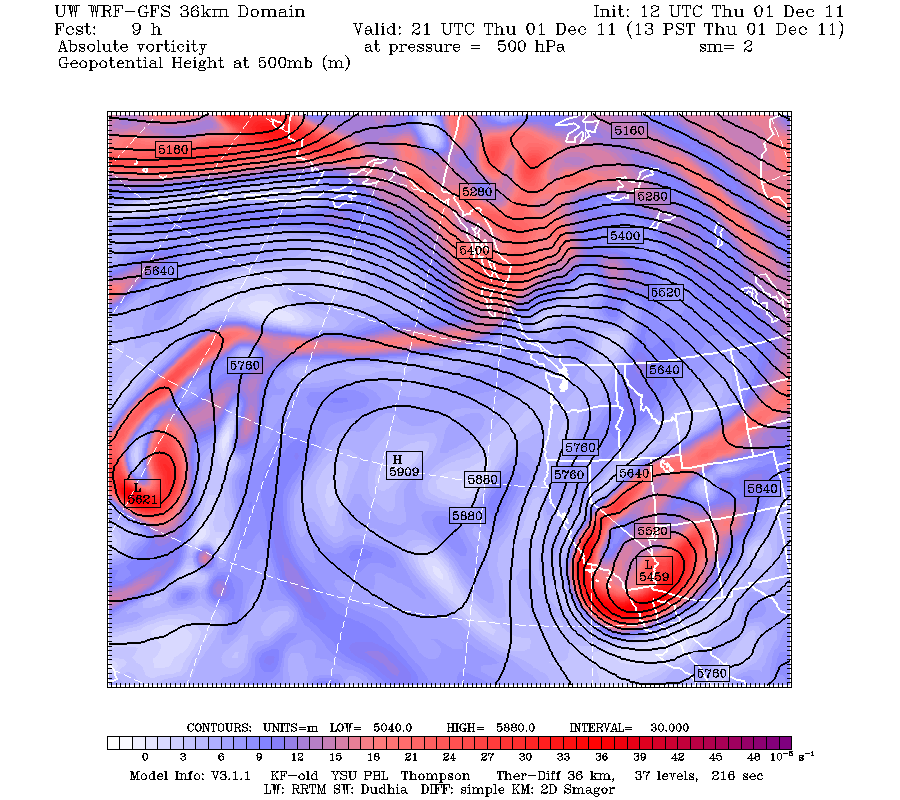
Valid 01:00 pm PST Thu, 01 Dec 2011 – 9hr Fcst – UW 12z 36km 500mb absolute vorticity, heights
72 hours later, it is much further west.

Valid 01:00 pm PST Sun, 04 Dec 2011 – 81hr Fcst – UW 12z 36km 500mb absolute vorticity, heights
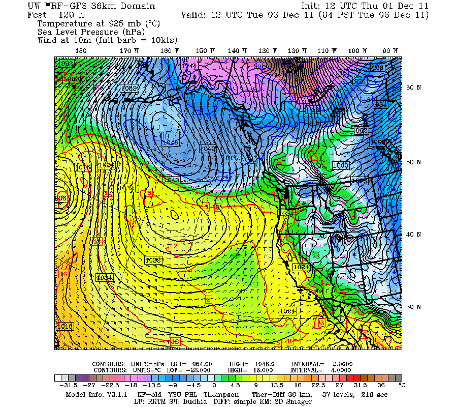
By the 120 hour forecast, it is even further west, and a trough is approaching the Pacific Northwest.

Valid 04:00 am PST Tue, 06 Dec 2011 – 120hr Fcst – UW 12z 36km 500mb absolute vorticity, heights
Let’s take a look at the surface temperatures at this time.
Valid 04:00 am PST Tue, 06 Dec 2011 – 120hr Fcst – UW 12z 36km 2m temp, 10m winds, SLP
You can see a bunch of very cold air shifting towards us. Again, this is at 120 hours.
But what happens in the hours beyond this is what is truly exciting.

Valid 04:00 am PST Wed, 07 Dec 2011 – 144hr Fcst – UW 12z 36km 2m temp, 10m winds, SLP
Look at all that cold air! There are very strong gradients by the Fraser River Valley, so Bellingham would get blasted with high winds if this were to occur.
And finally, 168 hours out – the day 7 forecast.

Valid 04:00 am PST Thu, 08 Dec 2011 – 168hr Fcst – UW 12z 36km 2m temp, 10m winds, SLP
That is some frigid air. And you don’t even want to know about Montana.
But, alas, it is beyond 120 hours. I will be watching the models closely to see if this comes true.
Charlie