Atmospheric rivers, like the one over Western WA right now, are strong, narrow, and often slow-moving streams of mild, moist air stretching from the subtropics to the midlatitudes.

Credit: UW Madison
When this air slams into terrain like the Cascades or Olympics, it is forced to rise, resulting in even more clouds and even heavier rain. The strongest atmospheric rivers, like those that occurred in November 2006 or December 2007, can drop a foot of rain in less than 24 hours all the way up to 11,000 feet, resulting in major flooding over the rivers of Western Washington.
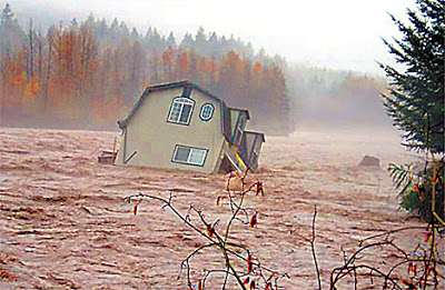
Credit: Michelle Matchet of the Lewis County Sheriff’s Office
But the stronger the orographic enhancement on windward slopes as air rises, cools, and saturates, the stronger the rainshadowing on leeward slopes as the air sinks, warms, and dries. And one of the most difficult things to communicate during an intense atmospheric river is that some locations could see major flooding, while others could see a steady drizzle or even be dry altogether. Additionally, atmospheric rivers often arrive from a more westerly direction than most of our typical wintertime systems, meaning the Western Washington rain shadow tends to migrate from its usual location over Sequim to Snohomish or King County.
Today is a perfect example of just that scenario. Take a look at the satellite imagery from this afternoon, showing a fast-moving atmospheric river bringing flooding to many rivers off the Olympics & North/Central Cascades while Seattle and Everett see much thinner clouds with light rain and drizzle.
Dramatic rainshadow today with the atmospheric river over Washington. Flooding on several rivers over the Olympics and North/Central Cascades, but much lighter rain and lower cloud tops over North/Central Puget Sound. Pretty easy to see on satellite. #wawx pic.twitter.com/iHpcq687xb
— Charlie Phillips (@GeoduckChuck) January 12, 2022
Expect a similar pattern for the rest of the evening into tomorrow morning, with torrential rain in the Olympics and North Cascades, light rain for Seattle, and just drizzle for Everett. The AR should lift north tomorrow afternoon, but Thursday will feature rain and slightly cooler conditions as a more typical front comes through. However, Friday should be partly cloudy and completely dry, with mostly cloudy but dry conditions continuing for Saturday.

Next week looks pretty uneventful… we could see a few weak systems, but nothing like the active weather we’ve seen so far this month. And definitely no arctic outbreaks/snow threats for Western WA for at least the next 10 days!
