October 12, 2012
4:18 P.M.
As promised, I’ll give you guys a brief overview of the Columbus Day Storm of 1962 since it has been 50 years since it happened. Unfortunately, I had a seizure before the presentation and was still in the ER when the presentation started. Trust me, I tried to convince those hospital techs, but they like to be careful. I’m quite alright; I do have epilepsy and I have had a string of seizures over the past two weeks, but apart from a sore tongue, I am fine. Hopefully, my neurologist will figure out what has changed and change my meds accordingly so I can stop having so many seizures and start going to weather events.
However, the good thing is that I do know a good bit about the Columbus Day Storm. It is, without a doubt, the most intense storm to strike the Pacific Northwest since the arrival of European settlers, and could be the most powerful extratropical windstorm to ever strike the United States since 1776.
The Columbus Day Storm was a freak of nature – an outlier – a singularity in severe Pacific Northwest weather events. It was by far the strongest wind event to ever hit our area, and it was the earliest as well. November, especially around Thanksgiving, and early December are the times when the Pacific Northwest is stormiest. How is it then, that our strongest storm occurred in early October?
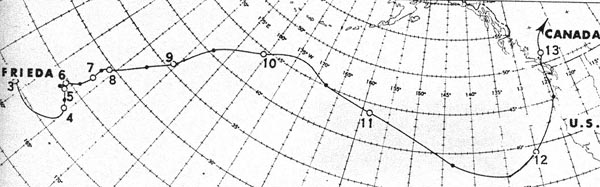
Well, the key here is understanding how tropical moisture gets entrained in the Westerlies. In October, ocean temperatures in the western Pacific Ocean are still very warm, and very strong supertyphoons can still form. The Columbus Day Storm actually started life as a typhoon – Typhoon Freda – over the western Pacific Ocean. As the typhoon degenerated and lost its tropical characteristics, it still retained a massive amount of warm air and moisture. This parcel of air was carried west across the Pacific Ocean all the way to the Californian coast, but once it was off there, the air associated with typhoon Freda collaborated with a 170+ knot jet stream in the upper atmosphere to promote cyclogenesis and form a storm of the likes we had never seen before.
After this storm formed, it raced up the Pacific Northwest shoreline. And folks, when I say “raced,” I am not exaggerating. After forming, the storm itself moved to the NNE at 40 miles per hour. This, combined with a minimum pressure of 960 millibars, the proximity of the low to the coast, and an extremely tight pressure gradient, made the Columbus Day Storm a step ahead of any storm seen before or since with respect to wind velocity.
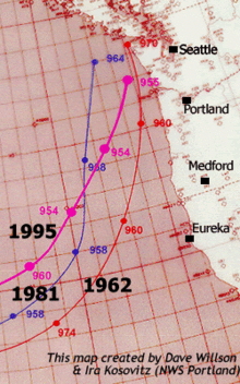
Folks, nothing has even come close. This map (see photo credit above) shows three of the Pacific Northwest’s biggest windstorm: the Columbus Day Storm, the November 14, 1981 storm, and the December 12, 1995 storm. The 1981 and 1995 storms were actually deeper, but they were a far cry from the Columbus Day Storm in terms of wind speed. Why was there so much discrepancy in the power of winds from three similarly-deep lows?
There were a variety of factors that made the Columbus Storm so windy, but three big ones were:
A.) How swiftly moving the storm was (this contributed to extremely fast pressure rises and falls which accentuated the strength of the wind)
B.) How compact the storm was. Whereas many extratropical cyclones are spread out over a very wide area, the Columbus Day Storm was pretty small in terms of area. Of course, it traveled over a huge area, so the damage was widespread, but the actual radius of the storm was fairly small.
C.) How closely it paralleled the shoreline. The Columbus Day Storm was much closer to the Pacific Northwest than the November 14, 1981 storm and the December 12, 1995 storm. The only exception is that the December 1995 storm actually came within the same distance to Seattle as the Columbus Day Storm, but the December 1995 storm was much bigger (this does NOT mean more powerful) in terms of area, so the pressure gradients were less intense.

Take a look at the December 12, 1995 storm. This storm was at least 5 mb deeper than the Columbus Day Storm, but it was much bigger, moved slower, and was further away from the coastline for most of the duration of its life.
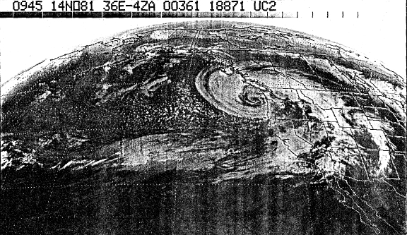
Here’s some satellite info of the November 1981 storm. Satellites weren’t too high-resolution back then, but it can give you an idea of what the atmosphere looked like over the Pacific Northwest on that day.
Sadly, there is not satellite data for the Columbus Day Storm, but we do have some surface maps that show the incredibly compact nature of the storm. This surface map was completed in 1966 by Lynott and Cramer, and I found it on Cliff Mass’ blog. It shows the storm at peak intensity, which was around 3 P.M. that fateful Friday.
.JPG)
Finally, no storm presentation is complete without me giving you a map of the actual winds that were witnessed, so here is a beautiful map of all the gusts in knots compiled by Wolf Read. To convert to miles per hour, multiply by 1.15.

If I ever get my hands on a video from Cliff’s presentation, I will listen to it, and relay what I have learned back to you. Until then, you’ll have to make due with this.
Charlie

