Thursday, July 11, 2013
10:05 P.M.
As the title says, my mother and I saw Volcano National Park today. It was a breathtaking experience… I’ll talk to Pele about that… I’d like to have my lungs back. Especially after breathing in all of that sulfur dioxide. But honestly, I couldn’t have imagined a better day. Below is a running script of things I wrote while I was in the car.
______________________________________
It’s 12:59 now… we probably got to the park entrance at 11 or so. So far, we’ve seen some pretty awesome things… we watched a cool video on Kilauea that gave us a history of some of the eruptions, but I think the coolest part was the voice of the narrator, which was highly reminiscent of the declaratory, patriotic voices giving the history of WWII and encouraging the U.S. citizens to enlist. The coolest thing we’ve seen so far are the steam
vents and panoramic views of the Kilauea crater. Inside the larger Kilauea crater is the Halema’uma’u crater which, albeit much smaller, is currently active. See the live cams above for snapshots. I’ll post these later when I have more time.
It didn’t start out raining here, but now it has transitioned to a “heavy drizzle.” This may seem like an oxymoron, but what I’m referring to is a multitude of small water droplets.
Alright: 5:09 Update
We’ve done a ton of things thus far today; after Kilauea, we went to the Jagger museum, the Halema’uma’u crater, some steam vents, some sulfur banks (which should be avoided by children, the elderly, and, according to our guidebook, ‘anybody eating lunch.’), Kilauea Iki, and the Thurston Lava Tube, to name a few. We finished by driving down Chain of Craters Road with a stop at some lava fields near Mauna Ulu before carrying on to the ocean cliffs at the end of the road. We stopped when cars cannot physically drive any further due to lava from a 1974 Kilauea eruption engulfing the highway. Still, we were able to see some massive waves crashing against the shoreline and a a really cool arch extending out into the sea – the Holei Sea Arch, as I learned later. at the terminus of the road. These waves had a lot of gnarl, but they were certainly not surfing waves…they crashed against a sheer cliff that rose ~150 feet. Besides, while there was indeed a swell, the waves were more of a hodgepodge of chop with whitecaps breaking everywhere.
Right now, we are driving to Ken’s House of Pancakes in Hilo. Apparently this is a Hilo staple and is open 24 hours a day. Seeing as my mom and I had light breakfasts, we are both hungry (though my mom to a MUCH greater extent). After reaching Hilo, we are planning to return to Kona via the north side of the island, which means we will have circumnavigated the entire island in one day while still spending six hours in the park. My mom is a trooper, and she passed a little bit of that spirit onto me.
I could talk about everything from invasive species to hydrofluoric acid, but if I tried to write all this stuff while on my vacation here, I’d have no time to do fun things, like deep-sea fishing (I’ll be on the boat in a little over 13 hours!) or rectifying my horrible tan lines from Micronesia by doing some sort of snorkeling or surfing. Yes, I’ll be wearing sunscreen… Banana Boat SPF 50 to be exact, but the only thing that would prevent be from getting sunburnt is one of those full-body suits that people wear when they are trekking through Antarctica. Therefore, I’ll humor you with my newly found worldwide-influenced vernacular for now, and when I get back to Seattle and have nothing to do other than fishing and playing saxophone, I’ll analyze all the pictures I’ve taken and science I’ve learned and put together some pretty schnazzy blogs. Oh yeah, I’ll talk about weather too.
Update 10:01 P.M.
Got back from eating pancakes, left Hilo a little before 6, and finally got back to Kailua Kona around 9. Waking up at 5:45. Night. No word from anybody in Micronesia… I’ve bugged them for info and pics, but they haven’t yet responded. Fingers crossed.
Ended 10:31 P.M.
___________________________
Started 1:37 P.M. 7/16/2013
Well, I’m back in Seattle, and it’s time to actually write about what I said I would write about earlier: the science behind my adventures at Volcano National Park. Unfortunately, I wrote a lot of stuff last night but Blogger did not save it, so I’ll just have to write it again. It’s ok, I could always use some qwerty practice.
Note: All pictures were taken with my Nikon Coolpix S6300 Camera on July 11, 2013, which is the day I went to the park.
Upon arriving at a parking lot in the park, we smelled that smelly smell of sulfur. Looking forward, we saw steam arising from small vents in the ground. Not surprisingly, these vents are called “steam vents” and are formed when water seeps through the ground, is heated by hot volcanic rocks buried underneath the soil, and rises back up again as steam. These vents smelled of sulfur, but the smell was not particularly potent.
Another thing about the steam vents is that the steam they expunge holds a LOT of water. There’s the invisible water vapor that can still be held by the localized area of hot air arising from the vent, but once this air rises and mixes with the cooler surrounding air, a lot of water vapor condenses into droplets, and this is visible as steam. Fog can be thought of as a much less intense version of this general effect of the air already being saturated with invisible water vapor and no longer being able to hold any more, so the remaining moisture in the air condenses out as microscopic cloud droplets. That is what happens with these vents… cool air can hold less moisture than warm air, so the remaining moisture condenses out of the air and is visible as steam.
You don’t get wet walking through fog, however, and you can get pretty damp pretty quickly by standing in front of one of these steam vents. This is just a testament to how much water these guys bring up from underground.
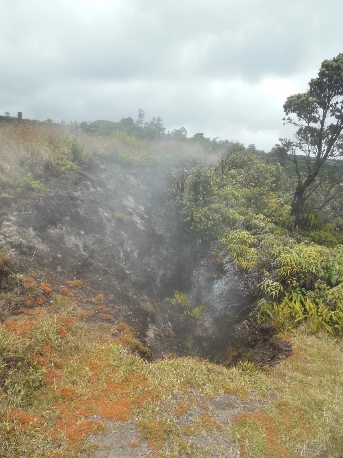 |
These steam vents are nothing to scoff at. If you jumped into one of these vents, you would not only fall an unknown number of feet but you may become scalded to death by the steam. Additionally, since these gasses have volcanic origins, they are chalk-full of hydrofluoric and sulfuric acid which, besides being hazardous to humans, eat away rock and leave behind dangerously thin crusts of surface ash that may appear homogeneous to the land around them, so it is wise not to get too close to these vents. I learned about this rock dissolution stuff after looking at the vents, so I have an excuse for being a bit too close. Some boy was injured in 1996 when he fell into one of these cracks, and you can check out the L.A. Times story here. Had he not grabbed onto some grass at the last moment, he would have almost certainly slipped into oblivion.
 |
| My mom standing next to a steam vent |
And folks, all of this steam stuff occurred on our walk to the visitor’s center overlooking the Kilauea caldera. Let’s get to our feature presentation.
Kilauea – The Most Active Volcano On Earth
 |
| Source: Hawaii Volcano Observatory, USGS – Retrived 7/16/2013 from Wikimedia Commons |
In Hawaiian, ‘Kilauea’ means “spewing” or “much spreading.” The Hawaiians knew this was an extremely active volcano, and that is what the “spewing” refers to – the nearly constant flow of lava that originates from the magma chamber underneath the volcano. As such, it is the current center of the Hawaiian-Emperor Seamount chain of islands, atolls, or seamounts that were formed by volcanic activity. It is the youngest part of the island of Hawai’i (Big Island), but it is not the youngest part of the entire chain; that title belongs to the undersea volcano Lo’ihi approximately 30 miles due east of South Point on Hawai’i. The volcano itself is 300,000 to 600,000 years old, but 90% of it is covered by lava flows that are less than 1,000 years old. Folks, this is not Mt. Rainier, or even Mt. St. Helens. The current eruption has been constant since 1983 – 30 years of lava. That is absolutely mind-boggling.


I tried to make a panorana-esque shot of the entire caldera, but it turned out pretty badly. The picture below is a satellite shot from space, and hopefully this can give you a better view of the structure of the caldera.
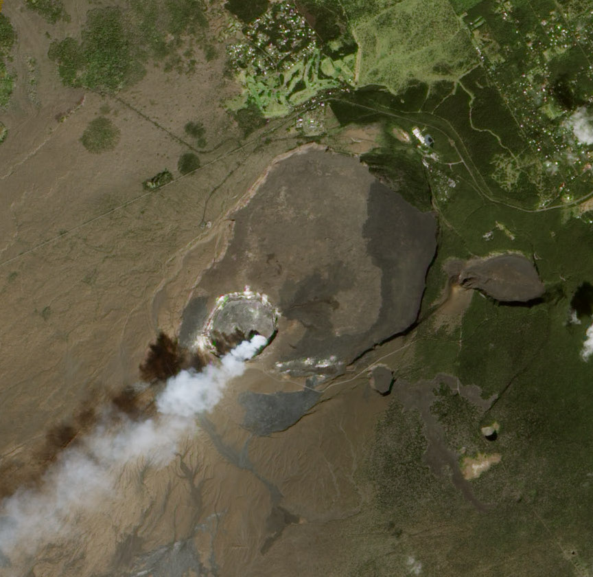 |
| Satellite shot of Kilauea on January 28, 2012 – Retrieved from NASA 7/16/13 |
There are several things that stand out in this picture. So let’s get to it.
1.) The Halema’uma’u Crater
See that miniature crater from which steam is erupting within the larger Kilauea caldera? This is known as the Halema’uma’u Crater and is the current ‘eruptive center within the eruptive center.’ It has constantly been erupting a cloud of steam, sulfur dioxide, and other volcanic gasses since at least 1983.

And yes, there is the famed “hot lava” within Halema’uma’u. I came to Hawaii when I was 5, and when it turned out that I couldn’t see any hot lava, I had an extraordinarily large temper-tantrum that may very well have been mistaken for a high pitched eruption from within the crater. When I was young, I was obsessed with volcanoes. You think I’m obsessed with weather now? This is NOTHING compared to my preschool through 1st grade infatuation with geology, and, in particular, volcanology. Although atmospheric science has taken the top spot, it is followed closely by volcanology and oceanography.
You couldn’t see the lava from where we were standing, so here’s a picture taken at night that shows the lava lake glowing below the crater. Parts of the park within the general caldera were closed due to an abnormally high risk of death due to an eruption of lava.
 |
| Taken 3/22/13 at 10:10:35 (after dark) by Wikimedia contributor TimBray – Retrieved 7/16/13 |
If you want a view of what’s happening inside the crater, check out this cam below. It is simply extraordinary.
http://hvo.wr.usgs.gov/cams/panorama.php?cam=HTcam
In fact, the whole USGS Hawaiian Volcano Observatory website is awesome; check it out here:
2.) Kilauea Iki
The satellite picture shows two additional craters outside of the larger caldera. I don’t know anything about the smaller one, but the larger one is called Kilauea Iki. Kilauea Iki erupted in 1959 and has not had significant volcanic activity since, but for November 14 to December 20 of that year, Kilauea Iki was extremely active and put on some fantastic shows. The picture below is a “lava lake” inside Kilauea Iki. These lakes are common throughout the region and are the reason why the surfaces of these craters are so flat. The most expansive example of this in Hawai’i is the entire Kilauea caldera, but they can be found in other places throughout the island as well. There may even be some remnant lava lakes on Maui, Oahu, or Kauai, but I have no clue. However, they probably had lava lakes on them when they were under the current Hawaiian hotspot.
 |
| Kilauea Iki filling with lava on November 14, 1959 – Retrieved from USGS on 7/16/13 |
There were also some incredibly strong lava fountains from Kilauea Iki. A lava fountain is exactly what it sounds like; a fountain of lava. Some of these lava fountains were incredibly high, reaching 1,900 feet above their eruptive center. Pretty impressive stuff.
 |
| A lava fountain on Kilauea Iki on December 12, 1959 at 7:00 A.M. Retrieved from USGS on 7/16/13 |
There were 17 separate eruptions in the 10/14 – 12/20 time frame. The first one began when the south wall of the mountain ripped open, and a “curtain of lava” a half mile wide flew into the crater. Kilauea Iki had erupted 90 years before, so a crater was already formed. With each successive eruption, the lava lake rose and rose, and with lava surging out the vent, huge waves of molten rock surged through the crater like waves in a nasty Columbia Bar crossing. The crater, which was 800 feet deep, was filled halfway with lava.
I’ll just stop and let that thought percolate through your mind for a bit.
The eruption finally ended when the lake rose high enough to drown the vent from which the lava was outpouring. The lava drained back down the vent but left behind a 50-foot “bathtub ring” of dark rock as evidence.
I took some pictures of the crater, and I have posted them below.
 |
| Overlooking the crater from a trail we hiked around the rim of it |
 |
| A steam vent of sorts inside the crater |
This was one of the most awe-inspiring eruptions ever recorded. As USGS scientist Don Richter (hint: there’s a scale named after him) said, “Our senses were overwhelmed by the eruption – we could see it, feel it, hear it, smell it.” The eruptions of Pinatubo and Mt. St. Helens may be more explosive and dramatic, but take a moment and imagine yourself staring at a fountain of lava over three times the height of the Space Needle. There is a mesmerizing component that these relatively gentle shield volcanoes have over catastrophic eruptions from stratovolcanoes.
3.) Different Rock Colors Within the Caldera
If you look inside the Kilauea caldera, you can see specific areas that are darker or lighter than others. I don’t know much about the origin or formation of these different colors, but if I had to guess, I would hypothesize that they were created by different lava flows originating from different areas at different times. The problem with that theory is that the surface of the caldera looks the same; there doesn’t look to be any overlying flows. Another theory which I think would be more plausible is that they were all part of the same lava lake at one time, but they had different characteristics and did not mix. Of course, the problem with that theory is that the transitions are pretty sharp, so there would have to be essentially no mixing of any of the lava, which, as a liquid substance, might not be very plausible. Lava is very viscous though, so it is quite possible that different lavas don’t mix that well.
This topic of lava flows leads me on to another very important subject (which is accordingly named)…
The Different Types of Lava Flows
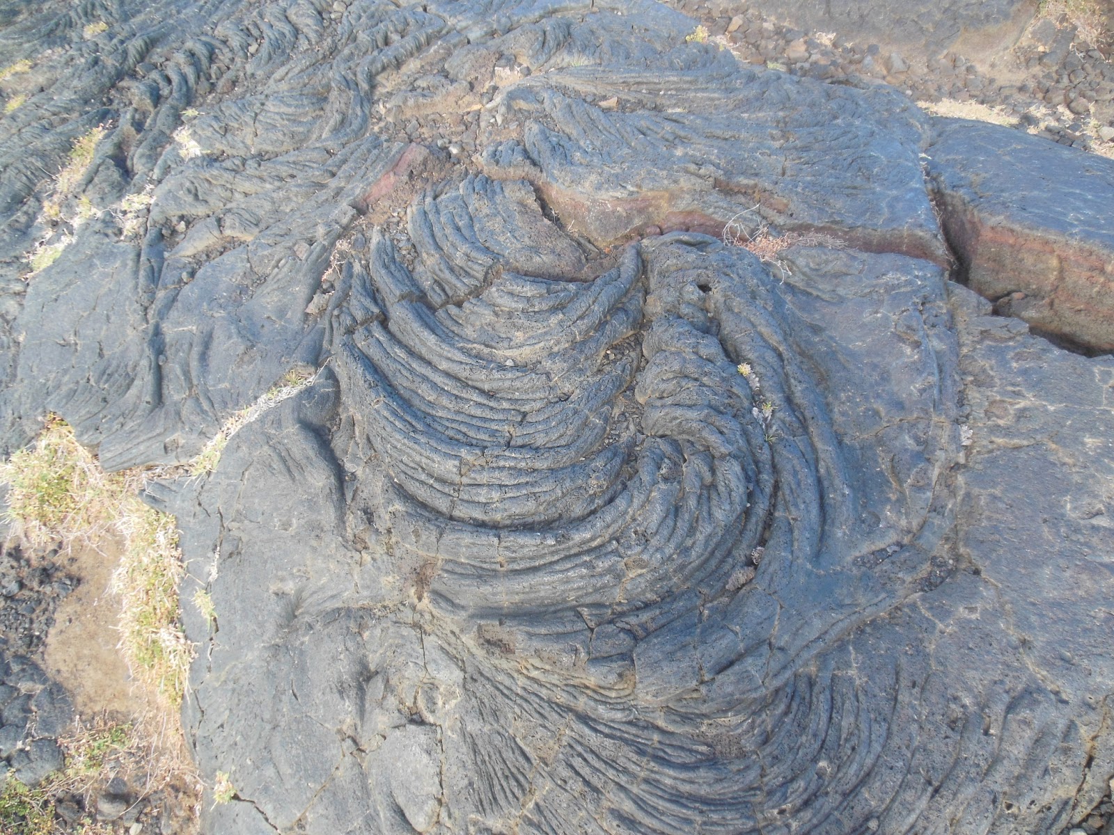
I’m sure there are many different types of flows. One-flow, two-flow, red-flow, blue-flow. But for simplicity, we are going to focus on two types of flows: A’a and Pahoehoe
I hope you haven’t had trouble understanding anything I’ve talked about. But if you only come away with this blog from one thing, it will be the difference between a’a and pahoehoe.
Short answer: Don’t cross a’a barefoot!
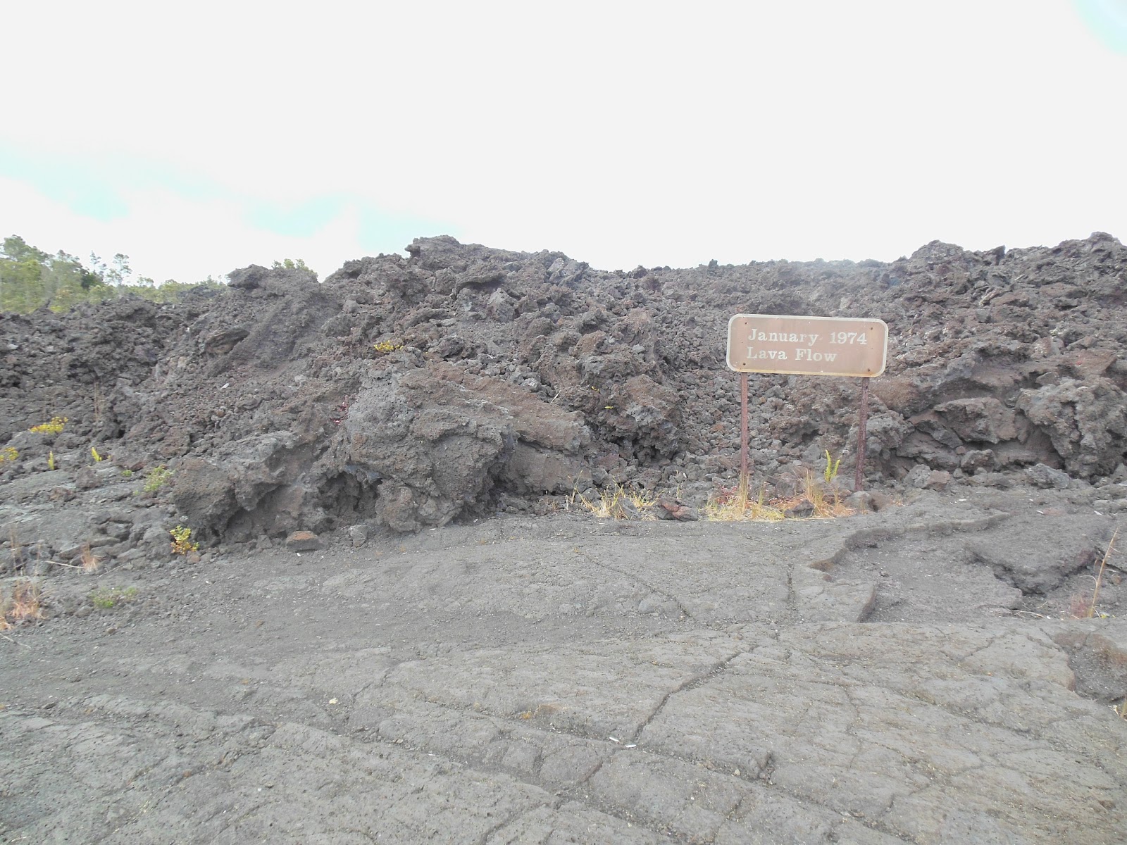 |
| Pahoehoe is in the foreground, A’a from a January 1974 lava flow is in the background |
Long answer:
Pahoehoe lava has a smooth surface texture, not unlike that of a pan of chocolate brownies. Additionally, they have little textures on them that provide a glimpse into how the lava cooled into solid basalt. Check out the pictures I took at the end of Chain of Craters road by the ocean.

A’a lava has an extremely rough surface, and it tends to remind me of the giant stones often around quarries, but only sharper and more numerous. Some a’a lava that I found had these incredible colors on the outside, with lots of blue/grey and copper-colored reflective material surrounding the rock. I don’t know what this is or how it was formed, but it sure is fascinating. The second a’a picture of a singular rock with an a’a background shows this well.

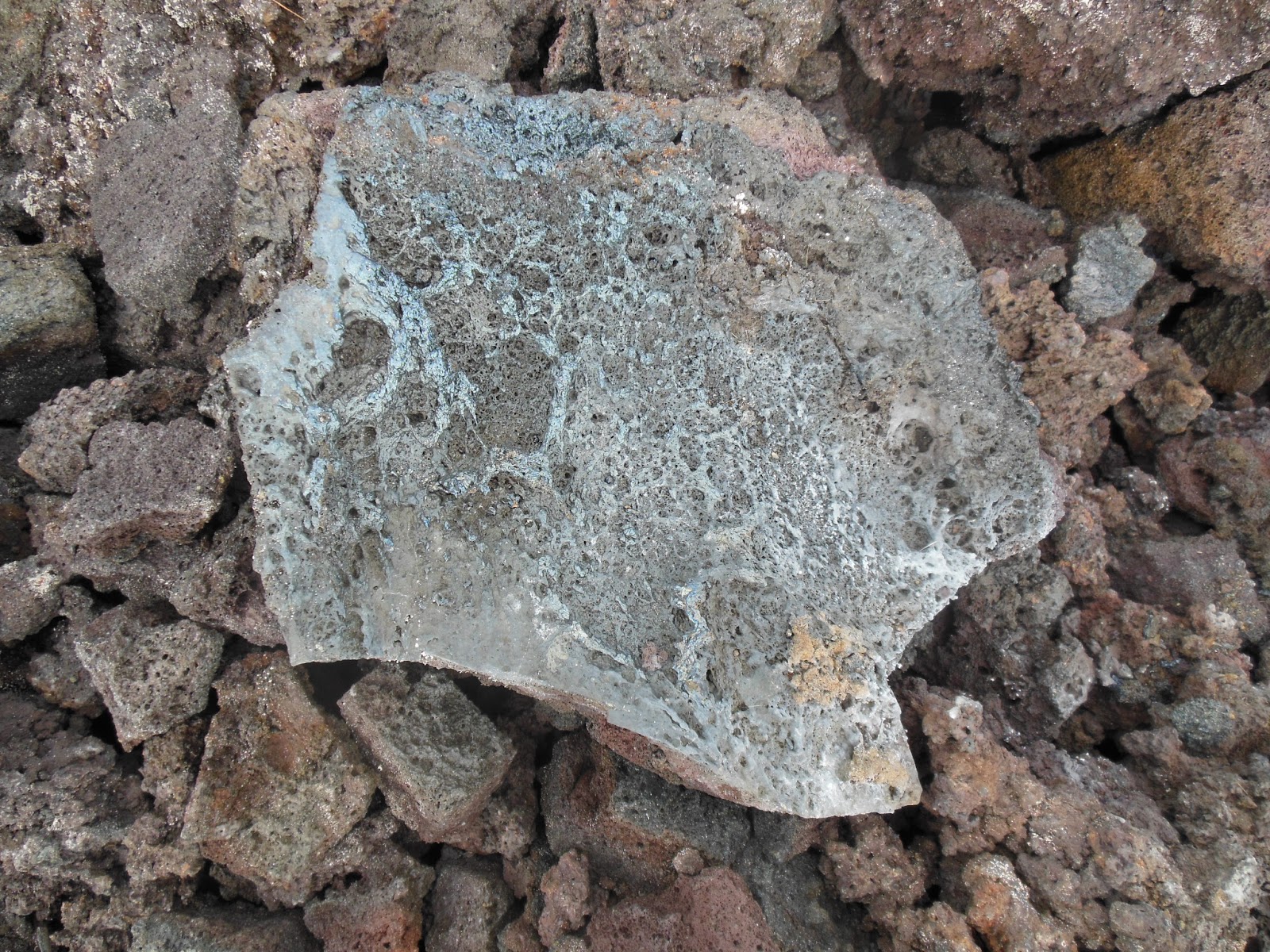
There are several differences in the way these two types of lava form. Pahoehoe tends to form in an eruption with a low rate of effusion (amount of lava discharged per unit time) while the opposite is true for a’a. Pahoehoe flows are more fluid and can spread across different parts of a landscape, but an a’a flow acts like a bulldozer and obliterates everything in its path. Pahoehoe flows can turn to a’a flows when there is a change in conditions or the pahoehoe simply loses heat and gas as it travels further from the vent from which it came, but it is hard for a’a to transition to pahoehoe.
Pahoehoe and a’a flows often come from the same eruption and there is no difference in chemical composition between them. This shows that the mechanism that determines whether the lava is a’a or pahoehoe is related to the physical conditions that the lava travels in rather than the chemical composition itself.
It’s getting kind of late here… 5 P.M. with essentially no breaks, but I’ll try and wrap it up.
The steam vents were cool, but they could not compare to Sulfur Banks, a location nearby where sulfur crystals could be found. There were a host of gasses that were emitted from Sulfur Banks, including sulfur dioxide and hydrogen sulfide. These specific gases react with each other to create pure sulfur and water, and this sulfur manifests itself in these stunningly gorgeous yellow crystals. Don’t touch them though… they are fragile and coated with sulfuric acid. These crystals were known as kukaepele, or the waste of Pele. I wonder why…
They sure don’t look like waste though, even if they may smell like it. Take a look at some of the pictures I took of the banks. They are absolutely stunning!
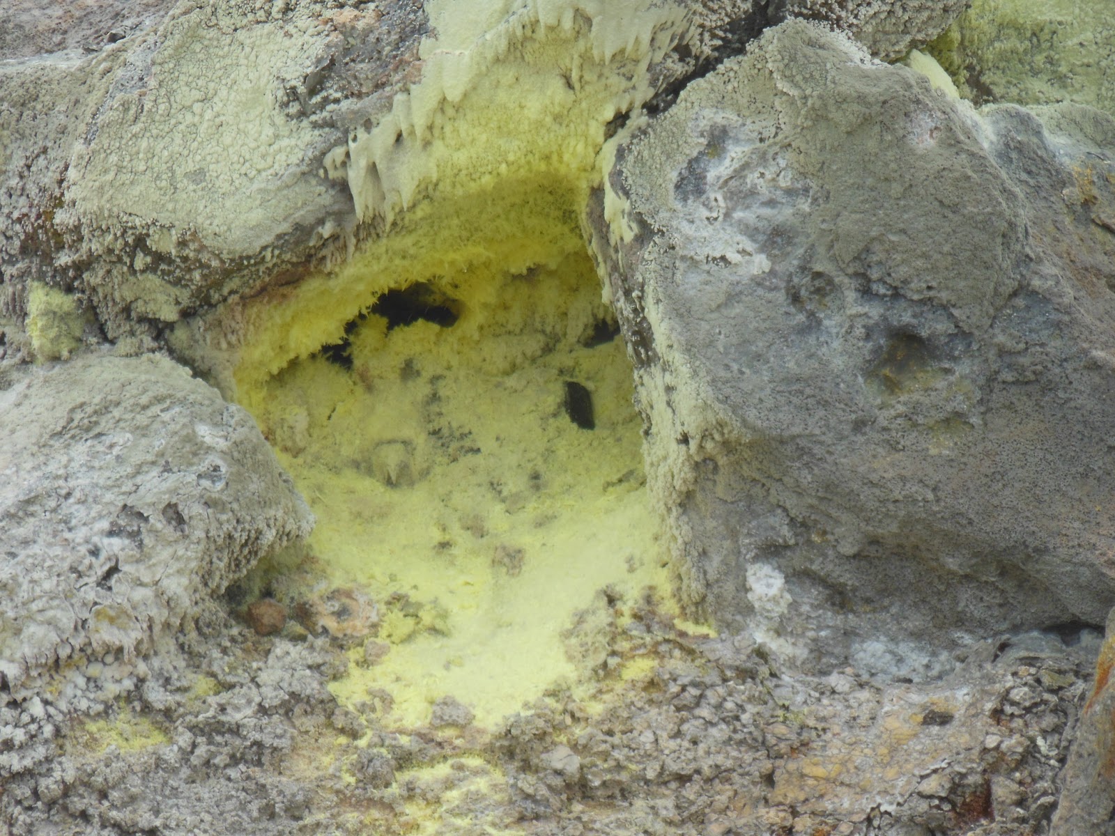 |
| Some individual sulfur crystals |
 |
| The banks as a whole |
These banks were formed when Kilauea’s summit collapsed 500 years ago. The summit collapse occurred because as the mountain continued to erupt, the magma reservoir under the mountain was gradually emptied. Eventually, the pressure upwards from the magma chamber to support the summit could not support the downward force of gravity, and the summit collapsed into a caldera. The collapse didn’t occur as one giant drop throughout the mountain… there was a “stepped” characteristic to the surface after the collapse, with the center of the caldera being the lowest and discontinuous step-like features increasing the elevation and gradually ending the caldera. Sulfur Banks is on a terrace on one of these steps. We talked earlier about how steam vents emit primarily water vapor and some other gasses such as sulfur dioxide. With Sulfur Banks, the water extends all the way down to the magma chamber, vaporizes, and, having a much high sulfur content, creates crystals on its way back up to the atmosphere
Pele is the Hawaiian goddess of volcanoes, fire, lightning, and wind. Pele is known for her creativity and passion, but most notably, she is known for her deep sense of love.
 |
| I could not find a certified public domain image of Pele, so this will have to do. |
Legend has it that every volcanic eruption in Hawaii is Pele’s way of longing to be with Lohiau, a young Hawaiian chief. Her home is the Halema’uma’u crater inside the Kilauea summit caldera. Pele is believed to control everything about a volcano, including when and where it erupts, and is one of the most important goddesses in Hawaiian religion.
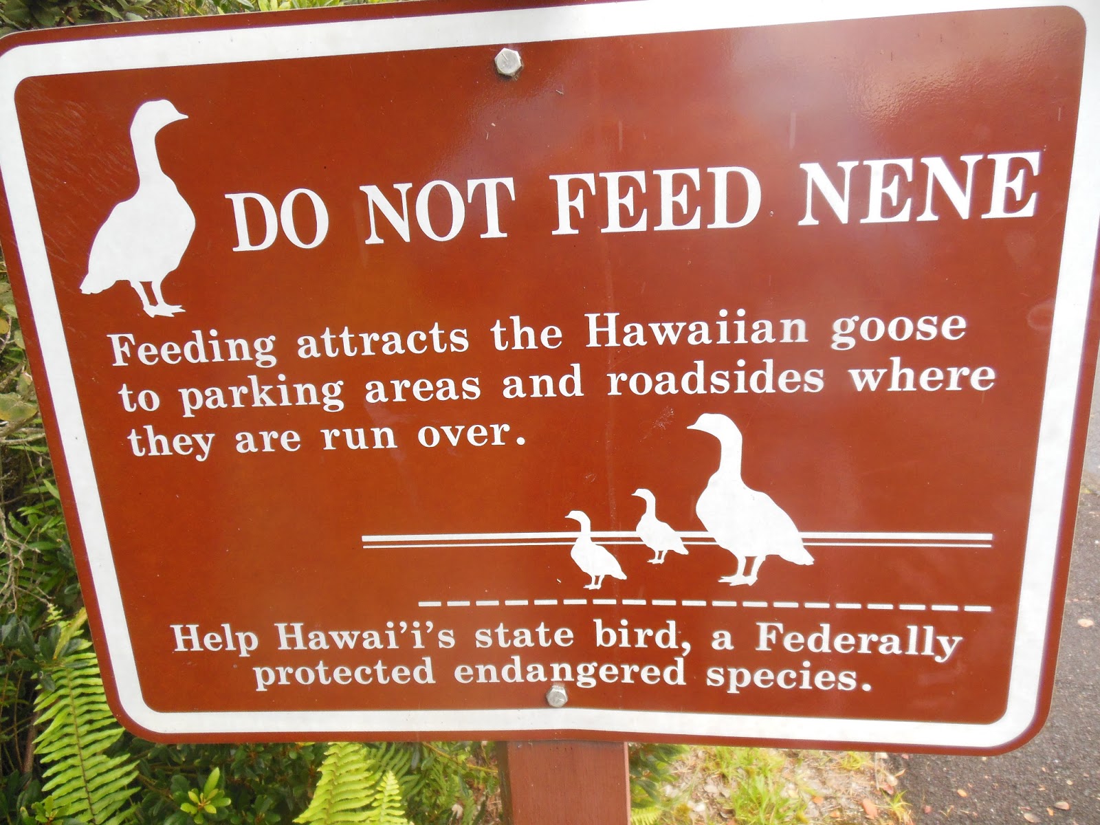
Unrelated to Pele is Nene, the state bird of Hawaii. We saw many nene on our drive around the park.

This bird… wow. Most birds run from cars and trucks. This one waddles towards them. We had to slow way down and try to convince the bird to get off the street while we were driving past it. I think we must have put up a pretty convincing argument, because we got him to get off the road.
In conclusion, however, this was an absolutely incredible day, and I’m so glad that I can share it with you in my blog.
Thank you!
Charlie
