Friday, August 9, 2013
3:20 P.M.
In many parts of the country, air conditioning is necessary during the summer months. Even in places with high and low temperatures similar to us (usually places that are close to the Canadian border, such as International Falls, Minnesota and Portland, Maine) generally have higher relative humidities. And Chicago? Fu’gett about it. And Texas? Fer’get bout it even more.
All people, myself included, benefit from what is called a “marine push” or “onshore flow.” In a typical Western Washington marine push event, cool air off the upwelled coastal waters of the Pacific flows into the lowlands through the Chehalis Gap and Strait of Juan de Fuca. This relatively cool and moist air brings cooler temperatures and clouds during the morning. This is our “natural air conditioning,” and is the reason why so few people in Western Washington have air condition.
But why do we even get an onshore flow? It’s not just Seattle – much of the West Coast experiences a similar phenomenon of cloudy mornings and sunny afternoons. San Francisco comes to mind.
 |
| Golden Gate Bridge on May 3, 2009 at 7:33 P.M. – Picture by Wikimedia user runner310 |
It is first important to understand the correlation between temperature and pressure. Let’s start with one of the fundamental rules of physics. When gasses warm, their volume expands while their mass remains constant. For our purposes, a parcel of air rises because it is less dense than the surrounding atmosphere. This is something everybody is familiar with. Does the picture below ring a bell?
 |
| Mass Ascension from the International Albuquerque Ballon Fiesta. Taken October 13, 2006 by Eric Ward and retrieved from Wikimedia Commons. |
Let’s think about it in mathematical terms. We know that density is equal to mass/volume, so let’s set up the equation d=m/v. In this equation, v (volume) is the denominator, and as the denominator of a fraction increases while the numerator stays constant, the fraction as a whole decreases in value. 1/2, 1/4, 1/8, 1/999999… you get the point. If we let m = 1 and v = 1, then d = 1. But if we let m = 1 and v = 999999, d is approximately 0.000001. The ratio of the old density to the new density is 1/0.000001 = 1,000,000 (one million). So the old density is around 1,000,000 million times greater than the new density. We usually don’t see differences in density that are that large, but you get the point.
The reason hot air balloons work is because they heat up the surrounding air inside their envelope until the entire person/basket/envelope system is less dense than the air around it, and it can rise. Hot air balloons are the oldest type of technology capable of carrying humans through the atmosphere, and as you can see above, they are still alive and well.
Now that we’ve established the relationship between density and heat, let’s look at some of the processes that cause marine pushes to occur.
__________________________________________________
In order to have a marine push, we need to have some marine stuff that is capable of being pushed. Thankfully, we have plenty of marine stuff, and that marine stuff is in the form of cool, moist air over the Pacific Ocean.
Still, why doesn’t Hawai’i get marine pushes? Why doesn’t Boston? They both have plenty of marine stuff, right?
Recall that an air parcel rises when it is hotter (and therefore less dense) than the surrounding environment. I’m going to show you some pictures I got off a program called Terrafin. Terrafin is a program that is aimed toward helping fishermen, particularly those targeting pelagic species, find water conditions that would be the most favorable for catching certain types of fish. Terrafin provides sea-surface-temperature, chlorophyll, geostrophic current velocity and dynamic height, and sea-surface-height anomaly charts to those with an account.
Although I only use it for fishing once a year when my family goes tuna hunting off Westport, it is an extraordinary program and provides a great hi-resolution look into what is happening out in the ocean. I highly recommend buying a year-long subscription.
Let’s take a look at the sea-surface temperatures off Hawai’i and Bahston.
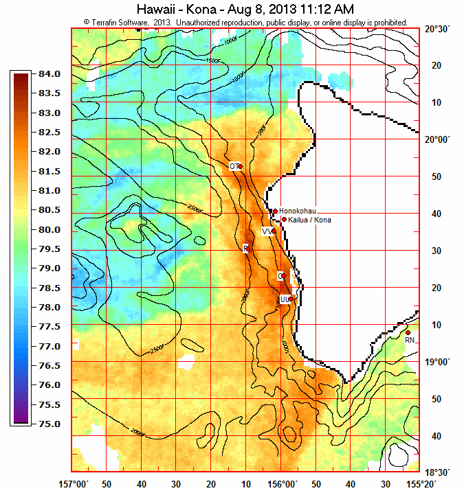

The lowest it gets off Kona is 75 degrees, but most of the stuff is over 80 degrees, which is the same temperature as the land on that side. The absolute lowest it gets off this section of the East Coast is 60 degrees, but temperatures near Boston are 65 degrees. The average high this time of the year for Boston is around 80, so this isn’t a huge temperature discrepancy.
Now let’s take a look at Washington and Northern California sea-surface temperatures. Some parts are not shown because clouds were covering the area at the time of the shot, and these types of satellites cannot approximate the water temperature if clouds are covering the surface.
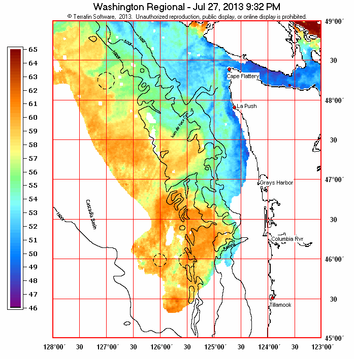

Much colder water is near the coast. Off Washington, the water is around 50 degrees. Off Brookings (which is actually in extreme southwest Oregon), the water is even colder: 44 degrees in spots. In both locations, there is a massive temperature difference between the water immediately off the coast and the temperatures of the land adjacent to the coast. Since cold air is denser than warm air, a localized dome of high pressure remains on the coast while the pressure drops over the inland areas each day as the air warms and becomes less dense. This creates a strong pressure gradient from high pressure over the coast to low pressure over land during the day, and this creates a very strong seabreeze. At night, the temperatures are around the same, so no breeze occurs. On another note, some places actually experience land breezes, in which the wind travels offshore because the water offshore is warmer than the temperatures on land. This generally occurs at night. The Pacific Northwest doesn’t get much of a land breeze because at night there is not that much of a temperature discrepancy between the land and the ocean.
Often times, these breezes leave evidence that they have occurred, even when they are not actually occurring. Take a look at this picture of a windswept tree off the coast of northern California. Since the pressure gradients off northern California and southern Oregon are very strong due to the strong temperature differences off the coast and onshore in the summer, the area is currently being investigated for the potential for offshore wind farms. There are already plenty of wind farms onshore in that area.
 |
| Photo Credit: Ted Goth – April 2010 |
Now, our feature presentation… the marine pushes that are unique to Western Washington.

First, we have the setup I’ve already explained. Cold air over the ocean gives a localized area of high pressure, while daytime heating creates lower pressure inland.

Because the Pacific Ocean is so cool, warm air that flows over it causes fog to form as it cools and can hold less invisible water vapor. Meanwhile, the inland areas are super sunny. Often, the fog will burn off in the morning and lead to sunnier conditions in the afternoon due to daytime heating along the coast, and these sunny conditions often translate to a pretty hefty sea breeze, particularly along the Strait of Juan de Fuca.
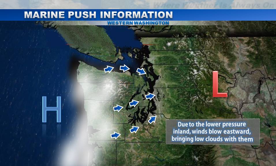
Due to our sea breeze, all this moist air blows into Western Washington through the Chehalis Gap and the Strait of Juan de Fuca.

As the sun sets and temperatures over Western Washington drop, this moist air off the ocean condenses into stratiform clouds over the lowlands, giving us our classic cloudy mornings.
* All these pictures were based off of ones from a KOMO article on the same thing, which you can find here: http://www.komonews.com/weather/faq/4306832.html. Tanner Petersen, CEO of WeatherOn, did the graphics for me. Send him a thank you by spreading the word about WeatherOn.
Portland actually does NOT get these marine pushes because there is no passage for air to flow through. Therefore, highs are generally 5-10 degrees warmer in the summer there than in Seattle. Marine pushes are not only a function of cold water and warm land… there has to be a pathway for the air to flow through.
My original stipulation for writing this blog was my observation that the visibility was worse in the morning and got better as the day went on. I could not explain this… the amount of particulate matter in the atmosphere didn’t change as the day went on, so why would visibility change? Well, I did some research, and figured it out.
When the relative humidity is high, water is more likely to bond to particulate matter in the atmosphere. When water bonds to particles, it makes them bigger, thus resulting in lower visibility. As the day goes on, the relative humidity decreases due to daytime heating (although the dewpoint stays the same, which means there is the same amount of water vapor in the atmosphere), and less water bonds to particulate matter. Therefore, visibility increases!
I could have just written those last two paragraphs, but I decided to give you the whole spiel. There’s no point in me explaining the finer points of a concept if you don’t have the basics down!
Thanks for reading, and enjoy the lightning tonight!
Charlie

