
In the wake of the incredible thunderstorms many locations around the area saw Thursday, I thought I’d write a review on the amazing and very uncommon weather we saw last week. In the interest of time, I will spend relatively little time reviewing general thunderstorm knowledge, but if you are interested, you can read a 4-part tutorial all about thunderstorms here. Additionally, I’ll blog a LOT more about thunderstorms next week, as I’ll be tornado chasing in the Great Plains!
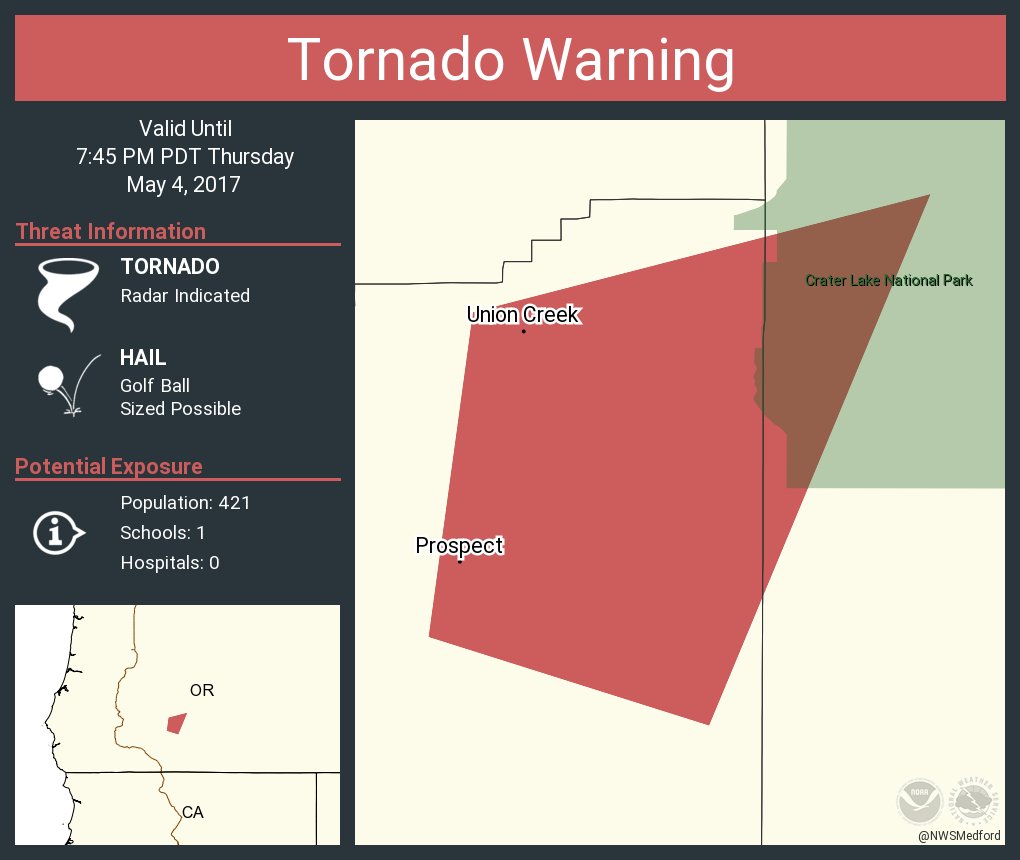
Thunderstorms are rare enough around here, but the thunderstorms we saw on Thursday were a whole different beast. We had it all: torrential rain, large hail, gusty straight-line winds, extremely frequent and widespread lightning, and even a tornado warning near Crater Lake in Oregon (no tornado was observed, but doppler radar indicated that one could form). All in all, we had 34 severe weather reports (17 for winds and 17 for hail), with several of these reports for high winds of 65 knots or greater and hail larger than 2 inches, which is bigger than a golf ball!
As I explained in last Wednesday’s post, these thunderstorms were so predicted to become so strong because we had a very unstable atmosphere. We had warm, sticky, southerly flow at the surface delivered to us via the combination of a ridge of high pressure and an atmospheric river stemming from Hawaii, but aloft, an upper-level trough with much cooler air began to infiltrate the area later Thursday, resulting in a sharp decrease in temperature with height.. This setup, with warm, moist air at the surface and cool air aloft, gave us a TON of Convective Available Potential Energy (CAPE) and allowed thunderstorms to explosively develop throughout the day. To add insult to injury, we had wind shear at upper levels that prolonged and further intensified these storms by separating the updraft and downdraft, preventing the downdraft from “raining” (or hailing) on the updraft’s parade and choking off the storm’s source of energy.
It’s relatively easy for us to get cool air at high levels when upper-level troughs drop into our area from the NW. However, it is difficult for us to see warm, moist air at low levels because the Pacific Ocean is so cool. Sure, we can get high relative humidities (it is rather drippy around here in the winter), but the approximate amount of water vapor in the air (i.e. the absolute humidity) is better described by the dewpoint, where the dewpoint is proportional to how much water vapor the air contains. Keep in mind that absolute humidity is dependent on temperature AND pressure, so using dewpoint to compare moisture content between different locations only works if the locations are on the same pressure level.
Our wintertime thunderstorms generally arrive when an upper-level trough drops into the area, giving us extremely cold temperatures aloft and chilly temperatures at the surface. In the summer, thunderstorms can occur when an upper-level trough dips to our south , giving us warm and relatively moist southerly or SSE flow at the surface while the upper levels remain cool, but not cold like they were on Thursday.
I had never seen a pattern here like the one that developed last week. In many ways, it is more analogous to the pattern that brings the massive supercell thunderstorms to the Great Plains, albeit a much scaled down version. The quintessential tornado setup for the Great Plains features extremely warm and moist air flowing northward from the Gulf of Mexico while an upper-level trough drops down from Canada, with a strong jet stream providing enough shear to separate the updrafts and downdrafts and make these storms spin. Counterintuitively, it actually helps to have hot, desert air come in at mid levels to form a “dryline” and add “convective instability” to the airmass, but I’ll talk about that next week!

Credit: National Severe Storms Laboratory (NSSL)
Our “Gulf of Mexico” wind was the moist air from the Pineapple Express + the strong ridge that gave us sunny skies and highs in the 80s, the upper-level trough dropped in from the Pacific instead of Canada, and the upper level winds were more southerly than westerly. I haven’t delved too much into soundings in recent blogs, but the most important thing to note here is the area between the red line (environmental temperature) and the dotted brown line (temperature an air parcel would have if risen from the surface). This is the all-important CAPE, and it is directly proportional to the potential strength of updrafts once the air parcel reaches the level of free convection (LFC), which is the “beginning” of CAPE and is labeled in the chart below. Our levels typically max out around 200 J/kg (especially with wintertime thunderstorms), but we broke the 1000 J/kg barrier nearly everywhere on Thursday.

Credit: Storm Prediction Center
Not every place with 1000+ J/kg saw large storms on Thursday, but many places did. Thurston County took a particularly heavy beating, as an extremely strong thunderstorm unleashed a “wet microburst” upon the area, providing extremely heavy rain rates (I saw a report of rates of over 14 inches per hour!) and damaging straight-line winds of over 70 mph. Microbursts like these form when air cools due to rain evaporating as it falls, causing the air to become more dense than its environment and sink accordingly. Melting hail can accelerate this process further, and in extremely wet microbursts like this one, the sheer force of the heavy rainfall can help to bring air down to the surface. When the microburst hits the surface, it spreads out in all directions, causing extremely strong and unexpected winds. It’s hard to believe the video below was taken in Olympia, Washington, but it was! The video was taken by Andrea Heryford and shared with King5 news.
38,000 PSE customers lost power throughout the state, most of them in Thurston county, and Lacey declared a state of emergency in response to the damage. Some of the damage pictures from this microburst are extremely impressive/sobering. I’m glad nobody was hurt!

Credit: Thurston County Sheriff Twitter
Though not all places saw the amazing winds witnessed in Thurston County, some extremely large hailstones fell in other areas. Bend, Oregon saw golfball-sized hail! High CAPE values like the ones we saw lead to strong updrafts, which can form large hailstones by suspending them aloft until they become too heavy and fall.

Forwarded to Little Bear Creek Weather by Jason Ponti, photographer unkown
Even if you didn’t see any severe weather, amazing clouds were visible from just about anywhere. Western Washington saw shelf clouds, which form on the leading edge of storms and are indicative of a strong downdraft. Check out a picture of an ominous cloud near Covington taken by Brie Hawkins of JBHawkins Photography/Little Bear Creek Weather and some mammatus clouds over Puget Sound taken by the Seattle National Weather Service.

Credit: JB Hawkins Photography

Credit: Seattle National Weather Service
Even if the clouds weren’t right over you, they still provided some spectacular photo opportunities from afar. Check out Michael Trofimov’s photo of a severe thunderstorm over Skamania County from Battleground, Washington. This storm had golfball-sized hail and grew to over 40,000 feet!

Credit: Michael Trofimov Photography

Credit: Michael Trofimov Photography
The radar loops showing these thunderstorms were very impressive. But for me, the most impressive thing we saw was storm splitting. Storm splitting occurs when a rotating column of air created by wind shear is tilted into the vertical by a strong updraft, creating two rotating columns of air – one that rotates clockwise and one that rotates counterclockwise. The presence of these splitting storms indicates that they had rotating updrafts, which are a classic characteristic of supercell thunderstorms and are extremely rare here in the Pacific Northwest.

These splits are certainly not as dramatic as some of the splits that occur in tornado alley, but any split is significant here in the Pacific Northwest. I saw two main splitting storms Thursday afternoon/evening… one NE of Longview around 2100 GMT (2 pm PDT) and one SW of The Dalles around 2200 GMT (3 pm PDT). This file is too large for me to upload, but you can check it out here.
And last but CERTAINLY not least, here are the lightning reports from this storm. Thank you Cliff Mass for posting this on your blog… I was a little tardy in getting a blog up on this event. There’s a notable gap over Portland and the Willamette Valley, but those facing west still saw a lot of strikes in the evening, and those facing east were treated to a brilliant lightning show just before midnight.

Credit: University of Washington (retrieved from Cliff Mass Weather Blog)
The Portland NWS estimated 9,000 total lightning strikes just in their forecast area alone. It’s impossible to know how many strikes of lightning there were, but we will know for future events when the GOES-R becomes operational and the Geostationary Lightning Mapper (GLM) records strikes!
Finally, here’s a picture of some lightning near Seattle from Matthew Charchenko. What a beautiful picture… I don’t think Seattle has seen lightning like this since August 10, 2013.

Credit: Matthew Charchenko Photography
In conclusion, this storm slightly exceeded my expectations – I knew we would see strong and potentially severe storms, but I wasn’t expecting to see golfball-sized hail or that crazy wet microburst near Olympia. Most storms ended up developing north of Portland away from me, but it was still fascinating to see brilliant lightning show over the Cascades late at night. I can’t wait to go storm chasing next week! And yes, I will be VERY active on this blog over the next 10 days.
Have a nice Hump Day!
Charlie
