FINALLY!
It’s one thing to be overjoyed at the first stormy forecast of autumn, but to actually see the moderate rain, gusty winds, and even the mountain snow associated with it is nothing short of wonderful. And believe it or not, another storm is right on its heels!
Let’s just cut to the chase and take a look at some webcams from around the Pacific Northwest. You can find these webcams and a few more on our Washington Cascades webcam page, and I plan to add many more throughout the winter. It appears as though the southern Washington Cascades and Northern Oregon Cascades picked up the greatest amounts, with several inches falling above 5-6000 feet at both Paradise and Timberline.

Credit: National Park Service

Credit: Timberline Lodge
Discovered with the help of Amar Andalkar’s Ski Mountaineering Website
Lesser, but more widespread amounts were found in the lower elevations of the northern Cascades. I couldn’t find any Mt. Baker webcams, but there was a dusting of snow by Roundhouse Lodge at Whistler. The snow has already become patchy… we are still in astronomical summer, after all.

Credit: National Operational Hydrologic Remote Sensing Center (try saying that five times fast!)
The culprit for all this mountain snowfall? An upper-level trough directing cool, moist, and unstable air into the region. Upper-level troughs are associated with cool air aloft because they draw down air from polar regions.

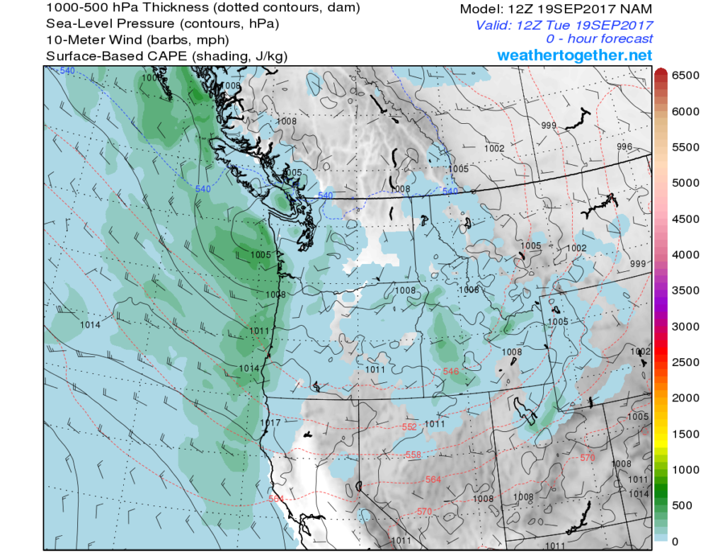
While temperatures at the surface cool substantially, they do not cool as much as those at higher elevations, resulting in a sharper decrease in temperature with height and a more positively buoyant (unstable) atmosphere. The models show a decent amount (for our area) of CAPE, which stands for “Convective Available Potential Energy” and is a numerical figure that quantifies the positive buoyancy of an air parcel. It is “potential” because the air parcel must be lifted to the level of free convection (LFC) for it to tap into CAPE. If you are curious about all this stuff, I suggest you read an article I wrote on Skew T charts here, which are are essential for understanding CAPE, the LFC, and many other measures of atmospheric stability.

In their latest AFD (area forecast discussion), the Portland NWS mentioned the chance of a few thunderstorms for the coast both today and tomorrow. We’ve already seen quite a few lightning strikes over the coast over the past 12 hours, and the radar shows that more showers are on the way.

Credit: Mark Nelsen’s Cascade Access Web Page

Credit: University of Washington
Forecast:
Models have been very inconsistent in the details over the past couple days, but have settled on sending a weak low pressure system into southern Oregon this evening. The main feature with this will be a “deformation band” that forms to the north of the low and will bring a shot of heavy rain to SW Washington/Central Oregon late tonight into tomorrow morning.
24-hour rain rain totals currently appear to be in the range of 1-2 inches for most places, with isolated amounts of 5 inches. More importantly, hourly rates could reach could approach half an inch an hour during the peak of the heavy rain, which is expected to be at approximately 5-8 am tomorrow morning.

Credit: UW Atmospheric Sciences
While this will do wonders for extinguishing the Eagle Creek fire, it could also cause flash flooding and set off a few landslides. As such, the Portland NWS has issued a Flash Flood Watch for the northern Oregon Cascades through Wednesday morning, which may be upgraded to a warning later today.

Credit: Portland NWS
Looking ahead to Thursday and beyond, we’ll dry out but remain cooler than average as this upper-level trough slowly moves east. By next week, a ridge will develop off the coast and build over the area, giving us a return to more seasonable September weather with plenty of sunshine.
Hurricane Maria:
Finally, a brief “update” (does it count as an update if you never wrote a blog in the first place?) on Hurricane Maria. Maria ravaged Dominica Monday afternoon (local time) as a category 5 storm with sustained winds of 160 mph, making 2017 one of only 6 seasons to have multiple category 5 storms and only the second (the other was 2007) to have multiple landfalling category fives. Moreover, both of them have landed in the Leeward Islands with truly catastrophic results.

Maria briefly weakened to a category 4 after making landfall but has since regained category 5 strength and is now headed straight towards Puerto Rico, where it is expected make landfall as a category 5 or high-end category 4 storm. The storm will pass very close to the Dominican Republic, and the jury is still out on whether it will make landfall there as a major hurricane or stay slightly offshore. By the weekend, it will take aim at the Turks and Caicos and Bahamas before finally heading out to sea.
This link shows an animation from the GOES-16 of Maria approaching and making landfall over Dominica yesterday afternoon. Our new GOES-16 satellite allows us to get a much better view of the structure of these incredibly intense storms and help improve forecasting by allowing us to more accurately monitor things like eyewall replacement cycles. The file is quite large… that is why I have not shown it here.
That was a long blog for a few inches of snow! Sometimes, you let your enthusiasm get the best of you. But I am so incredibly excited to kick off the 2017-2018 storm season, and I hope you are too.
Have a great Tuesday,
Charlie


2 Comments
Love your post and your enthusiam! Charlie, you are the Cisco Morris of PNW weather forecasts!
That’s a pretty high compliment! Now all I need is a catchphrase. 🙂