
Now that we are officially in autumn, I can hardly contain my excitement for storm season to get underway. Our transition from autumn into winter is fast and furious; in only 1 1/2 months, we’ll be in the stormiest period of the year, and there’s even a chance for lowland snow by then! No month exemplifies this transition better than November 2010 – I remember playing “flyers up” in the mid 70s at Garfield High School in Seattle on 11/3, and 3 weeks later, we dropped to 14 degrees after an arctic front moved through the area and gave us a surprise snowstorm that goes down as the second-most-memorable snowstorm of my life. The first was the early-morning convergence zone of December 18, 2008 (you can read about it on the site history page).

Credit: NOAA Online Weather (NOW) Data
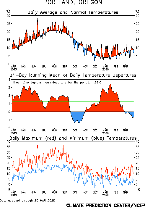
But even though our transition from autumn to winter is blazingly fast, our transition from winter into spring is painfully slow. Notice how much more quickly the average temperature falls during the autumn than it rises in the winter and spring. This was particularly true last year with our warm November and downright frigid December/January. We finally dropped below average for the first “semi-extended” (more than a day or two) period since early June to end September, and more chilly weather is on the way. Could it be a sign of things to come? I sure hope so!

Credit: Climate Prediction Center
I posted in the PDX WX Analysis Facebook Group to see if anybody had any insight as to why temperatures fell off more dramatically during astronomical fall as they rose during astronomical winter, as I was having trouble coming up with any concrete ideas. I got some great insight from the folks there, so I’ll share it with you here on this blog.
Thermal Inertia:
Thermal inertia is the resistance of an object to temperature change when subject to an external source of heating or cooling. I knew that thermal inertia played a role, but I couldn’t quite put my finger on any specifics (it didn’t help that I was running on 90 minutes of sleep either). Thankfully, the PDX WX Analysis group came to the rescue, and Chris Callais (one of my coworkers at Avangrid Renewables) and Dr. Janet Guss Darwich, a research analyst specializing in human nutrition, provided some particularly poignant insights about thermal inertia.
One of the main things Chris pointed out was the differing heat capacity (and thus thermal inertia) of the ocean vs. the atmosphere. For those unfamiliar with the concept of heat capacity, it is the ratio of heat added to a substance to its resulting temperature change. Because the heat capacity varies depending on the size of the object, we’ll refer to another, related measurement called the “specific heat,” which is simply the heat capacity of an object for a given mass (for example, 1 gram). Different objects have vastly different specific heats – liquid water has a very high specific heat, taking 4.184 Joules (a unit of energy) per gram to raise its temperature 1 degree Celsius, while the atmosphere’s specific heat is more moderate, only taking 1.005 Joules/gram to do the exact same thing. At 0.920 Joules/gram, asphalt has an even lower heat capacity than air, but the main reason it heats up so much under the sun is due to its extremely low albedo. If you want to walk barefoot on asphalt, do yourself a favor and hose it off first. Due to its high specific heat, the water absorbs the heat like you wouldn’t believe!

Credit: Hyperphysics: Georgia State University Department of Physics and Astrononomy
Because water has such a high heat capacity, it takes longer to warm up and cool down than air. Since the planet is 70% ocean, this is one of the main reasons that the warmest and coolest months (usually July and January for most places in the Northern Hemisphere) are offset from the highest and lowest amounts of solar radiation (summer and winter solstice, respectively). Take a look at the difference in timing between the average annual temperatures for Duluth Int’l Airport and Lake Superior.

Credit: lakesuperiorstreams.org

Credit: NOAA Coastwatch, retrieved from mlive.com
From the autumn equinox to the winter solstice, both the air temperatures and lake temperatures are falling dramatically. But even as temperatures begin climbing in Duluth midway through January, the lake is still cooling off, moderating the temperature rebound at Duluth. This lag isn’t just confined to Lake Superior – the same trend is apparent at Buoy E01 off Central Maine and many other locations throughout the world.

Credit: Nick Record, seascapemodeling.org
To summarize, the high specific of water means that there is a significant lag between water temperature and the change of seasons. Even though air temperatures in many places begin to rise in January, the fact that water temperatures are still decreasing until mid-March in most places slows the transition from warm to cold.
It’s also worth mentioning that the temperatures in the upper-atmosphere also lag the temperatures at the surface in most places. For Green Bay, notice how the surface temperatures bottom out approximately two weeks earlier than the temperatures at 500 mb (approximately 18,000 feet). This is because the ground more effectively absorbs and radiates heat back to the atmosphere, so it is quicker to respond to the increase in solar radiation.


Credit: Storm Prediction Center
This lag is MUCH more pronounced in the Pacific Northwest – our minimum surface temperatures are around the New Year, while our minimum upper-air temperatures are in early March! But for us, this lag is due more to a pattern difference than a massive discrepancy between the amount of radiation absorbed/emitted by the surface compared to the atmosphere. In the winter, we often see relatively warm, southwesterly flow aloft, while in the early spring, our flow becomes more northwesterly and we often get cool upper-level troughs dropping into the area.
If the Earth had no heat capacity, the temperature minimums and maximums would ideally line up exactly with the seasons. You’d also have extremely large swings in temperature between day and night, and Earth would be inhospitable to life. Heat capacity may slow our transition into spring, but we oughta be thankful for it too!
Albedo:
Another reason why temperatures cool off more quickly in the autumn than they warm in the winter is due to the effects that snow and ice have on the Earth’s radiation budget. As the days rapidly shorten after the autumn equinox, temperatures fall rapidly at higher latitudes, resulting in the buildup of snow and ice. Snow and ice have a high albedo, meaning they are very effective at reflecting incoming sunlight out to space. Other objects, such as water and trees, have a very low albedo and absorb around 90% of incoming solar radiation.

Credit: MetEd Comet Program Introduction to Climatology Module
After reaching a minimum in September, sea ice begins to build, and as it does so, a higher and higher percentage of incoming solar radiation is reflected back out to space. This, combined with rapidly shortening days and lowering sun angles, helps accelerate an already swift transition from warm to cold. The relationship between snow/ice cover and temperature is an example of a positive feedback; increasing ice cools the Earth (especially the higher latitudes), which in turn increases ice, and so on.
As the graph of arctic sea ice extent below shows, sea ice cover can rise 200% from the minimum in mid-September to the winter solstice. This abundance of snow and ice makes things very cold in the arctic and actually keeps temperatures in many places below freezing well into March. As a result, sea ice increases 15% from the winter solstice to its maximum in Mid-March, further slowing the transition to warmer weather despite the rapid increase in solar radiation.

The ice-albedo feedback is the reason why the Arctic has experienced such a dramatic decrease in sea ice from global warming and played a key role in accelerating/amplifying past ice ages. Antarctica hasn’t experienced the same dramatic effect as the arctic because the ice caps there are a couple miles thick, making it much more difficult for them to melt during their summer.
Credit: National Snow and Ice Data Center
Snow extent in the Northern Hemisphere reaches a maximum in January, but compare the increase from the autumn equinox to the winter solstice compared to the slow decrease from the winter solstice to the spring equinox. This is because (1) snow during the transition into winter is often the first snow of the year, resulting in a rapid buildup in extent, and (2) new snow falls on top of the seasonal snowpack throughout the year, making it deeper and more difficult to melt come springtime. In fact, total Northern Hemisphere snow mass peaks in March (Key et al., 2015).

Credit: National Snow and Ice Data Center
As you might expect, there is significant overlap between thermal inertia and albedo when it comes to seasonal temperature changes. For example, thermal inertia slows the melting of snow and ice, which in turn increases the albedo of an area and further slows warming.
Speaking of the swift transition from autumn to winter – take a look at the upper-level pattern the models show for the middle of next week. If this was occurring even a month and a half from now, we’d be talking about an arctic outbreak and the potential for lowland snow. For now, we’ll just have to settle for temperatures dipping down into the upper 50s with a chance of rain, particularly on Wednesday. I’m looking forward to it!

Well, that’s it folks. Thanks for reading, and have a great Saturday night!
Charlie


1 Comment
Very interesting article, Charlie! Thanks for investigating. Of all of the effects you mention, the snow/ice cover are what stand out to me as the major influence (first Autumn snow cover quickly initiating a drop in temps, resulting in more snow, etc., then the max snow cover taking a long time to fully melt delays Spring warming).
I’m hoping for some lowland snows this winter too! Time to pull out and clean my snowboard.