Since Christmas, the storm track has shifted south to California, bringing heavy rain and mountain snow to the Golden State. Parts of the Sierra Nevada have seen over 20 inches of liquid-equivalent precipitation, much of it in the form of snow. The most recent tempest occurred on January 4th and 5th. The image below shows […]
A Very Tricky Snow Forecast Today, More Snow Possible Later This Week
Snow is falling over Western Washington and parts of NW Oregon this morning. I’ve been riding the train down from Seattle to Portland and saw close to an inch in the higher elevations near Centralia. I’m now in Kelso and everything has switched to a cold rain, with no snow accumulation to be found. This […]
Cold and Wet For Memorial Day Weekend
We are finally starting to see some summer-like weather over the Pacific Northwest. I went for a nice bike ride on Sunday down to West Point in Discovery Park, and the weather was absolutely perfect, with highs touching 70 degrees at Sea-Tac and a mix of clouds and sun. Tons of riders were out on the Burke-Gilman […]
Lowland Snow Tonight? It’s Possible For SW Washington and NW Oregon
Yes – the rumors are true. There is a chance of lowland snow tonight into Monday morning for Southwest Washington and Northwest Oregon. Some spots over Washington have already seen some snow showers this morning, but the main threat – and the focus of this blog – will be the snow potential Sunday night/Monday morning […]
Beautiful Weekend, Rain and Mountain Snow Arrive Midweek
Meteorological spring begins on March 1st, and you can feel it in the air. After 1.25” of rain on 2/27 and an incredible 2.97” on 2/28, the weather since Tuesday 3/1 has been tranquil, with partly cloudy skies interspersed with brilliant bursts of springtime sunshine. I was walking around the International District yesterday, and when […]
Calm Through Next Week, But La Nina Pattern Returns By End of Month
Beginning around 1/14, a strong ridge of high pressure began to form over the Pacific Northwest, and although a few weak systems passing over it have brought a few sprinkles to Western Washington and Oregon at times, the weather is dead calm compared to the extreme mountain snow and river flooding we had to begin […]
A Review of the December 2021 Arctic Blast and January 2022 Snow/Flooding
On Friday, Seattle was cut off from the north, the south, and the east due to flooding from the Chehalis River inundating I-5, extreme amounts of snow in the Washington passes, and all roads out of Vancouver BC being closed due to heavy snowfall. None of these individual events are unprecedented – the Chehalis spilled […]
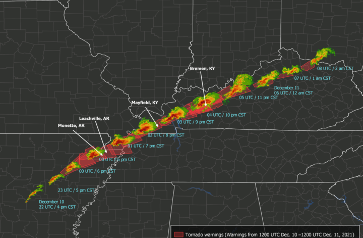
Record-Setting Tornado Outbreak Devastates South and Midwest
Last night, a rare, catastrophic tornado outbreak occurred over portions of the Southern and Midwestern US. As of Saturday afternoon, 34 people were confirmed dead, with an estimated 75-100 deaths across Missouri, Illinois, Tennessee, and Kentucky and potentially 50-70 deaths in Mayfield, Kentucky alone. Most deaths were due to a series of tornadoes – or […]
My Skagit River Flooding Adventure, The Week’s Forecast, and Mountain Snow In The Extended
When I was younger, my mom and I would always explore Seattle and look for the biggest puddles to (safely!) drive through after heavy rain events. We knew all the key spots – Lake Washington Boulevard through the Washington Arboretum always had some rather shallow but very lengthy puddles, and there were also quite a […]
Gobs of Mountain Snow This Week
I’m a firm believer that it’s important to pick up a winter sport if you live in the Pacific Northwest. It could be snowshoeing. Or perhaps heli-skiing is your cup of tea. It doesn’t matter the sport – all that matters is that it requires mountain snow. Why do I hold such a strong belief? […]


