Wednesday, October 6, 2010
Many people would be surprised to find out that the Pacific Northwest gets some of the biggest floods in the world. The reason why it is not common knowledge is because the places that flood are usually sparsely populated (like Snoqualmie or Concrete) or have no people at all (like many places on the Olympic Peninsula). Why do we get such huge floods? Besides, if anything, we are known for our light rain and dreary days. Even though Seattle has secured itself as a rainy city, it gets 20 inches less rain per year than Miami in the “Sunshine State.” How can these floods be explained?
The Pacific Northwest occasionally gets huge storms off of the Pacific that have tapped into tropical moisture just off of Hawaii. That is already one ingredient for disaster, because it means we will be getting heavy rain (lots of available moisture) with high snow levels. But what really makes these tropically-fed storms flooders is the fact that usually, as they travel off to the northeast from the southwest, they drag their cold front right over us and stall it. This means that we not only get a very strong storm headed our way, but that we have it around for a long time. Often, it will be raining consecutively for as much as 24 hours, and often that continuous rain will last for even longer, particularly in places with lots of terrain where orographic flow produces more precipitation. Combine that with a 10,000 foot freezing level and rainfall rates as high as a half inch per hour in the strongest of these storms and you have a recipie for disastrous flooding.
Since this moisture often comes from Hawaii, these storms have been dubbed “Pineapple Expresses.” We have had several of these in recent years, including a one in 2003 that gave the Sea-Tac airport 5 inches of rain in one day, an all time record, but I’m going to be focusing on two more recent ones in 2006 and 2007 because they were more powerful overall and still had a significant impact on Seattle. Take a look at the 2006 one below.

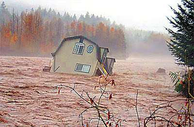
See how it is stalled right over the region, with a huge moisture plume going all the way back to just north of Hawaii? That is a classic Pineapple Express. It brought a ton of rain to the area, and the Mt. Rainier National Park area in particular was extremely hard hit, receiving 18 inches of rain in 36 hours. The park was devastated. I think one of the more amazing photos I’ve ever seen is actually from that storm. Take a look below. Yes, that’s a house. It sat on the banks of the Cowlitz River before the river rose over its banks and eroded out the foundation.

Lets talk about our other big storm, the Great Coastal Gale (shown above). This storm actually occurred from December 1 to December 3, but most of the rain occured between the 2nd and the 3rd. This storm is special because it brought extraordinarily high winds (I talked about that in a previous blog post). In fact, look at this picture.

All those trees were brought down by wind alone! An absolutely amazing storm. Waves off of the coast were measured to be 40 feet tall, and this storm brought down the nation’s largest Sitka spruce which was like 500 years old or something, suggesting it could be a 500 year event. In the hundred year history of real weather observations here, it is unprecedented in many factors.
Let’s talk about the flooding aspect of it though. Some places got 15 inches of rain in a day in Southwest Washington and Northwest Oregon. There was so much rain, in fact, that overflow from the Chehalis actually submerged I-5 underwater. The Chehalis broke its record crest by a huge magnitude with this storm. The photograph above shows flooding over I-5 in that region.
Wow, my computer froze a whole bunch and this took me 1 and 1/2 hours to write. But it was worth it. 🙂
Charlie


