Monday, November 22, 2010
6:22 P.M.
WOOHOO!!! I can’t believe this is happening. Winter storm warning and 2 inches of snow and counting! The models predicted zip. Cliff Mass predicted zip. Scott Sistek predicted pretty much nil. I gave you a 5% chance of snow. The National Weather Service was just ignoring the models and going on their own judgment, which I thought was silly because one of the models was very very consistent (the GFS) in showing no precipitation whatsoever for us. Well, they were definitely wrong. And we have gotten very cold. I just got a report from Nicholas Efthimiadis of an air temperature of 23 degrees with three inches of snow. The extremely cold weather and extreme warm weather in Alaska due to a huge ridge over the central Pacific that is making all this possible in the first place has given us something I thought I would never see in my lifetime. Barrow, Alaska, the northernmost point in the U.S. and well within the arctic circle (they are seeing no daylight right now) is warmer than us. That is truly phenomenal. They are 25 right now. We had a high of 32, they had a high of 34. I don’t know what else to say but that I’m completely blown away. I can’t ever recall a time of that happening.
So what is happening tonight?
Right now we have periods of light snow that I expect will intensify in the next hour or so. Now, most weather guys would tell you that and just end it there. But I’m not content. This blog is about explaining WHY some things happen, so that you can leave each read with a better understanding of Pacific Northwest weather and have an appreciation for it.
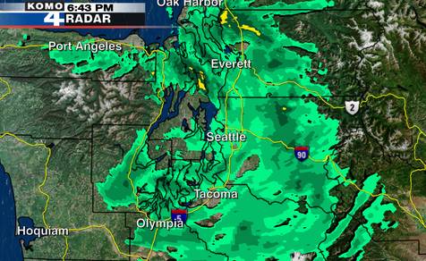
As you can see, there are some snow showers around the area. There is not much upper-level motion in the atmosphere right now – that is: the precipitation isn’t really moving – but as you can see, there is a fairly wide swath of snow to our north, with some embedded heavier rates (like the yellows you see). Now, this isn’t moving much, but it is moving to the south very very slowly. Snow has already increased around my area, however. There is a good chance that this feature could give us quite a bit of snow, especially it stalls over us and intensifies. By quite a bit of snow, I mean above 4 inches. That is a possibility, particularly if this feature has a convective element to it. A convective element is pretty much instability in the atmosphere.
Alright, so we got that out of the way. What will happen tonight?
The models have been pretty consistent with wind. I haven’t seen the new GFS come out, so this is the model from this morning, but I suspect that the forecast will now be for even higher winds because the low that did come in was MUCH stronger than forecast. I’m sure you were able to figure that one out. this will create tighter pressure gradients. I would not, under any circumstances, be surprised to see a 80 mph gust up by Bellingham. Even Seattlites will encounter brisk windchills in the teens with gusts up to 40 miles per hour, or perhaps even 50 miles per hour in spots. I will look again at the new models when they come out tonight and update this forecast. But anyways, here’s a graphic for 10 P.M. tonight, showing some rather high wind gusts from the northeast, especially by Bellingham. Windchills there will be below 0 in most spots. Cold temperatures combined with losing power present a danger, so if you know people who lose power or do lose power, do things to keep warm. Start a fire. Get a blanket. Use a generator if you have one, but do NOT under any circumstances put the generator in your house. This causes asphyxiation and you will die.

Credit: University of Washington Atmospheric Sciences
The San Juans in particular will get pounded. There may be some freezing spray, so it is a very bad idea to be out there. Storm force winds and frigid temperatures. Don’t be out there tonight.
We’re all familiar with the sense of anger we feel when a weatherman gets our hopes up for a snow day only for that snow day not to come to fruition. This seems to be particularly true when students put off their homework in expectations of a snow day and get bad grades as a result. If I had a final and I was lazy and the snow forecast didn’t consolidate, I’d be absolutely furious at the weatherman. If I mess up and your grades are affected, there is an official 24 hour window from the beginning of the school day to the next where you may make me the scapegoat for all your academic misery.
Of course, the issue of people hating weathermen is going to come up, although I think it applies more for when snow IS forecasted and doesn’t come true. It’s easy to say “why didn’t we think this” in retrospect, but the fact is, weather is a prediction. You never for sure know what is going to happen until it already is happening. So the best we can do from events like this is learn from them, and if we see a similar situation evolving in the models, take it with a grain of salt, because our models are not perfect. There lies the main difference in forecasting between the two powerhouses of Pacific Northwest weather prediction, the National Weather Service’s chief forecaster Brad Coleman and UW’s atmospheric sciences professor extraordinaire Cliff Mass. Cliff goes with the models more, while Brad has more human input. I’m generally with Cliff, although I do definitely take historical context, satellite, radar, and other stuff into context. He does too. Two years ago, the models were forecasting snow, but it was a really chancy situation and nobody believed it would happen. NWS said slushy accumulation of an inch possible. I said we could have 4 inches. We got 6. It’s hard though, so cut us some slack.
The snow is increasing and will continue to increase. Tomorrow will be VERY cold. I need to eat dinner with my family, but I will look to make another update later tonight. Recap – up to 4 more inches of snow is expected tonight as this feature moves down from the north, keep an eye out for convection, and wear a coat. And PHOTOGRAPHERS!!! Take some shots tomorrow, it will likely be the clearest day of the entire year. Extremely low humidities, and the mountains will have snow. Parents are getting anxious. Ciao. 🙂
Your local weatherman,
Charlie Phillips
FOR THOSE INTERESTED IN POSTING SNOW TOTALS – Post them as a comment. Hardly anybody comments on my blog. I’d like to change that!!!

26 Comments
for your benefit: 4.5 inches now. View Ridge, 200 ft or so
About 3 inches where it's accumulated, but the wind on Capitol hill blew the street and sidewalks into solid ice.
Wow, nice work, Charlie! A job very well done. You are definitely my trusted weatherman forever.
4 inches, Rainier Beach, around 230 feet
This is extremely helpful, honest, and current! I can't believe I haven't considered you as my up-to-date local weather forecast source before. That will definitely change. Thank you Charlie Phillips!
3.25 inches in the Montlake banana belt, 8:00 PM, approximately 60 feet elevation.
4 inches, 22.8 degrees, blowing 35+ 150feet Milton
http://www.wunderground.com/weatherstation/WXDailyHistory.asp?ID=KWAMILTO2
Nice work, Charlie!
2.75 inches in Leschi, 300 ft. elevation.
Time for hot chocolate…
I'm not really sure about elevation, but I live in the Central District (20 minutes walk from Garfield, but lower elevation) and the snow level is about 1 inch or less
2-3 inches, greenwood, 8:30PM, 150 feet maybe?
About 2 in. here in Lake Forest Park. Still snowing strong!
Trace to inch here…in Portland, OR.
First time to blog. Do you have andy with the picture because he quit weather and we consider him a "traitor"? Or something else. Just curious.
Sorry, should have made it clearer. I love Andy. Favorite weatherman BY FAR. This is just a joke that my friends put up because they get really mad when snow forecasts don't materialize. See the disclaimer. Didn't mean to leave a bad impression or hurt anyone's feelings!
4.75 inches at 2150 hours in Montlake, still coming down strong. What a great night! I'm upgrading my elevation to 90 feet, just for the heck of it.
And you are??? You don't impress me one bit. Late Monday evening the forecast had changed, the low did not dip as far south as most models had showed. The forecast was then changed before midnight. Then again 6am. Your information is all after the fact. I would like to see you do some forecasting of future snow events around the Pacific Northwest BEFORE it happens. Prove to us you have what it takes.
Thanks Charlie, I'm an avid fan and trusted follower! I rely on and brag about you way too much, this information was all too helpful. Can't wait to see a new post!
I agree that it would be even better if there were more weather forecasting, but your blog stands out because it gives the explanation and reasoning I need to learn. I don't think you're trying to "prove" anything by the way, I hope you're not? Because I'm even more impressed that you've turned what was/is an interest into something resourceful and amazing!
Ps. You impress me a lot!
-Vinsy
elevation is 320 feet over here in Greenwood, snow levels are as high as, wait for it, 6 inches up in this b***h
I should clarify after seeing that last comment from someone else in greenwood saying they had 2-3 inches. The snow level in most places around here is probably around 3-4 inches right now, but I found one spot on the sidewalk by my house that somehow had 6 inches accumulated, so I'm going with that
titas
Thanks you guys! And yes I will have more "forecasting" in the future, I just couldn't really make a forecast before because I was studying for all these tests Sunday night. When I found out I didn't have school I decided to talk about this, and now I will forecast the wind and other stuff coming up! And no I'm not trying to prove anything, I'm just trying to share my passion!
5 inches at my house, 50 feet on Lake Washington Blvd, a mile north of Leschi. Pretty impressive. Snow is winding down though.
Thanks for the support everyone! You are the reason I do this, and your nice comments/excitement about snow/bugging me about school closures just reaffirms that this is what I want to do.
5-6" here in Ravenna, about 200'
Will- i made a snowman that's about a foot high, should i change my comment to 12 inches?
haha actually there are about 5 or 6 inches now!
We've got about 4 inches up here in mount baker, but because of the wind, it's kind of hard to tell. I think I'm at around 200 to 300 feet.
I got 1 & 1/8 inches – to be precise – here in West Seattle. We be up at elevation 350.
Wauw, and that post at 10:01 PM yesterday musta been some news reporter guy fearing some future competition! I stays with Vinsy. You've got a passion and you're doing something about it!!