Wednesday, March 28, 2012
10:53 A.M.

Photo Credit: Jenni Whalen
So, I was talking a peek at the weather models this morning, and unfortunately, this morning’s runs look even wetter than before! I’m not complaining, as this will be great for our mountain snowpack, but it is sure to be an inconvenience for many around here.
Let’s take a look at the extracted GFS temperature and precipitation for both Seattle and Portland. These screenshots are courtesy of Brian Schmit, who made the program. I entered the comments.
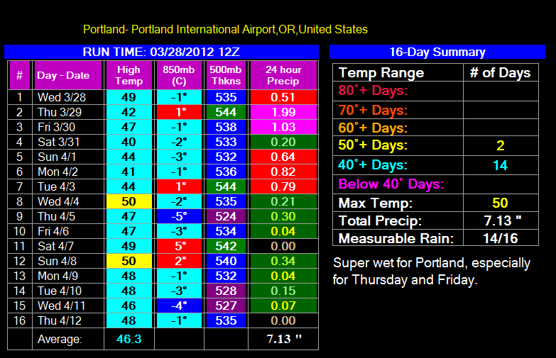
Portland looks to get soaked during this period. Seven inches of rain is a TON of rain. However, one should be careful when reading this extracted data, as the GFS model often overestimates rainfall for Portland due to it not picking up the effects of shadowing from the coast range. The big GFS model (as opposed to our WRF-GFS models at the UW) lacks the resolution to get great estimates of temperature and precipitation for specific locales. It also commonly underestimates high temperatures. Nevertheless, I would expect at least four inches of rain for Portland over the next two weeks, and possibly more. The snow will continue to pile up in the mountains.

The run for Seattle pretty much tells the same story. It is not quite as wet, as the big GFS model is better at accounting for the rain shadow from the Olympics than the rain shadow for the Coast Range in Northwest Oregon, but it is still pretty darn wet and cool. There is that odd 61 degree day, which just goes to show you how unpredictable a model is after around 5 days.
Bottom line: we will be wet and cool for at least the next week and possibly beyond.
Snowfall in the Cascades? You betcha!
Charlie

