
Monday, July 15, 2013
10:45 P.M.
Howdy everybody. I’ve been trying to readjust to Seattle time today, and I’ve taken a couple steps in the right direction. Today was not without its follies, however. I went fishing at the end of a street near my house, but I kept losing hook, line, and sinker because the wind would blow my slack line over a post near another person’s dock. When I reeled my line in, it would keep getting stuck on this rope that was attached to the post. At one point, I was running low on additional setups, so I actually jumped in the water (with a lifejacket) and swam to the post to try and save my setup. I use barbed hooks, so I wasn’t able to get my hook out, but I was able to recover my lead and swivel. After many failed attempts to catch a fish at this street end, I decided to head down the street to the nearest water treatment plant. Eating the fish in this vicinity isn’t probably the smartest idea, but at this point, I just wanted to catch something. Well, I cast my line out as far as it could go, but the whole place was filled with Eurasian Watermilfoil and my setup got stuck in the weeds. It is worth noting that although the entire lake is infested with milfoil (one of my friends runs a milfoil removing service and makes a lot of money from it), there is more milfoil here than inebriated Husky fans at a home game. That’s a lot of milfoil.
Although I was able to recover my setup, the wind blew my slack line away into a branch of the tree above. I hopped over the fence separating the water treatment plant and the lake and began carefully lowering myself down to the rocky surface of the lake, which was probably 8-9 feet below where I was originally standing. I then tried to reach to get a branch of the tree so I could pull it down and recover my setup, but it was just out of reach.
Therefore, I decided to jump for it. The first time, I jumped, but I couldn’t jump high enough, so I missed the branch and my bare feet landed on the rocks, which was extremely painful (I was wearing flip flops, which slipped right off). I was determined to get this setup though, so I tried jumping higher. Again, I missed it, and I fell harder onto the rocks, which just hurt my foot even more. By this time I was furious, so I decided to jump as high as I could and just deal with the pain. This third time, I was able to grasp the branch, but it broke in my hand. I fell down directly on my feet and cut open my left sole, and to add insult to injury, I lost my balance and fell completely into the lake. Finally, I gathered some common sense and used my limited, albeit finite and existing, cognitive abilities and found a way to strategically remove the line from the tree. I then limped home and called it quits. I’ll try again tomorrow.
Anyway, it’s good to be back. The fruit on the trees in my yard has grown, the grass is brown, the water is warm, our neighborhood nude beach is particularly bustling… all is well in Denny Blaine. Now let’s talk about weather.
The focus for the immediate future will be a chance of thunderstorms Tuesday night into Wednesday. Unlike the thunderstorms that typically hit locations east of the Rockies, these thunderstorms will have characteristics similar to those commonly found in desert regions. The air in which these thunderstorms are in will be warm and dry, so any sort of precipitation that falls will evaporate before reaching the ground. There might be a few hundredths of an inch of rain here and there, but the amounts will be very light.

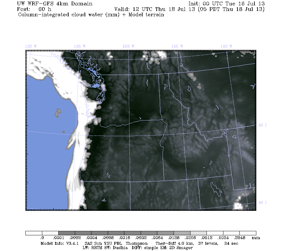
You can see the light amounts of rain over the area, but this map doesn’t really tell us a lot about what’s happening with the atmosphere. Take a look at these column-integrated cloud water images below, and notice how the water vapor changes in certain areas over this 24-hour time period.

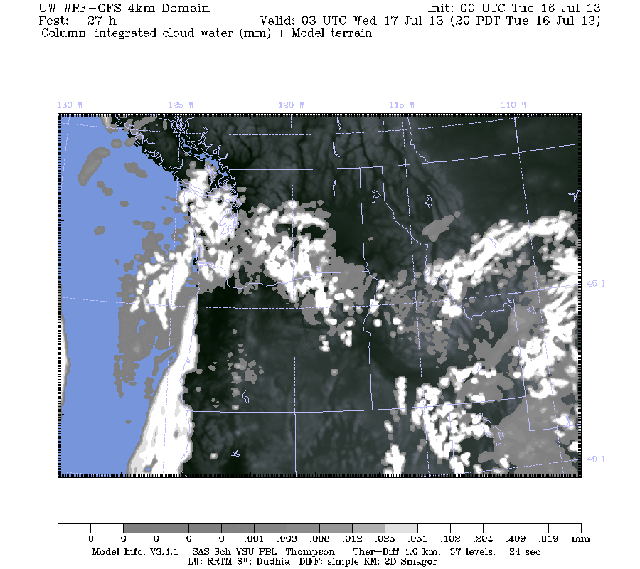
There are two main things to notice here. First is the explosion of convective clouds over Washington. Yet, if you look at the three-hour precipitation, you can see that the precipitation from these clouds is expected to be negligible. Second, check out the fog/stratus bank off the Oregon coast. We currently have a thermal trough moving up the coast right now, and this is what is giving us our warm weather. The stratiform clouds off Oregon represent the edge of the trough where a warm and dry offshore flow has transitioned to a cool and moist onshore flow with advection fog forming as a result. By Thursday, the entire Pacific Northwest coast will be covered in low clouds.
Inland areas, however, look to stay high and dry for the foreseeable future. We won’t be talking record heat, but no major marine pushes are in sight at this time.
Enjoy the lightning tomorrow. Dry lightning often leads to forest fires, so watch out if you have property in the affected areas, particularly if it is east of the Cascade crest.
No news from Micronesia, so I’ll use this as a placeholder until I get the scoop on what’s happening.
Ended 11:59 P.M. 7/15/13
Charlie 🙂

