
Hi all! I was in Seattle this weekend for yet another fantastic Pacific Northwest Weather Workshop, and I was actually lucky enough to present on some research I had done identifying substantial drops in wind power production at Avangrid! This was my first presentation at any sort of scientific conference (I was on a panel at the Workshop last year talking about forecast uncertainty and representing WeatherTogether, but this was much more involved), and it was a bit nerve-wracking with some unexpected challenges (things are always much different when you are presenting on a stage instead of your living room), but I came through in one piece, learned a ton, and look forward to giving more talks there in the future, whether I’m representing Avangrid, WeatherTogether, or somebody else entirely.

Now that I’m done with giving talks in front of an audience, I can return to my natural state of being hunched over a computer and writing blogs/coding weather models. What better way to spend your days as a single, independent, 25-year-old, right?

Today, I want to blog about our lack of severe weather over the Great Plains so far this year and what it’ll take for twisters to finally start spinning in Tornado Alley. I’m taking another Great Plains storm chasing trip from May 28th (Memorial Day) to June 7th with my friends Joey Sipos, a weather enthusiast and computer programmer I went chasing with last year (check out his Glider Island virtual reality game on Steam here!) and Chris Scragg, a journalism student at Arizona State University, a politics/science/technology reporter at their “State Press” university newspaper, and a fellow WeatherTogether blogger. The lack of severe weather we’ve seen thus far this season has been a blessing for those living in Tornado Alley, but we don’t want to spend our trip counting cumulus clouds and cattle. We’re looking for some twisters (provided, and I hope this goes without saying, that these twisters stay over rural areas).
The 2018 Tornado Season
The 2018 tornado season has been exceptionally quiet, especially over Tornado Alley, which is the stretch of the Great Plains along a north-south corridor from Central Texas to South Dakota. We simply haven’t had the ideal weather pattern for severe weather, which is to have an upper-level trough over the Intermountain West and an embedded shortwave trough over the Great Plains. The larger-scale upper-level trough helps direct hot, dry, southwesterly flow into the region at mid-levels and colder air at upper-levels, while the surface low associated with the embedded shortwave trough directs warm, moist southerly flow into the area ahead of the surface low’s cold front. Putting everything together, we get something that looks like this:

Credit: NOAA
Instead, we’ve had the exact opposite pattern, with a ridge in the West and a trough in the East. This trough has allowed cold air to surge down from Canada, keeping our warm and moist airmass necessary for severe storms at bay (quite literally, since this air originates from the Gulf of Mexico).

Credit: NOAA ESRL (Earth System Research Laboratory)
Since the Great Plains get most of their spring/summer precipitation from convection (thunderstorms), they have had a drier-than-average April.

Credit: Climate Prediction Center
Just how calm has it been? Both Oklahoma and Kansas have had zero tornadoes this year. Oklahoma has already surpassed its previous record for the latest tornado to begin a year, which was April 26 and was set in 1962. And although the Plains have bore the brunt of this tornado drought, the relative dearth of tornadoes extends eastward as well, as “only” 229 tornadoes have been reported this year, approximately 100 less than normal.
Tornado Climatology
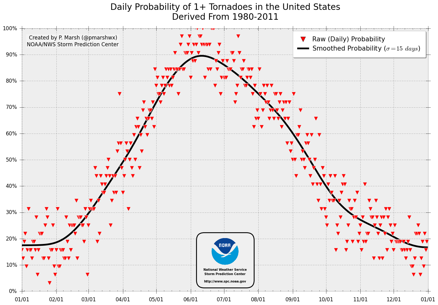
But taking a look at tornado climatology, it’s very clear that we still have a lot of tornado season to go. The potential for a tornado on any given day rises sharply from now until peaking in early June.

Credit: P. March/Storm Prediction Center
The total number of tornadoes on any given day looks quite different, with a substantial increase beginning in the second half of April, a peak in May/early June, and much lower numbers from August onward, even though the probabilities of a tornado occurring somewhere in the U.S. are actually higher at the beginning of August than the beginning of May. This is because springtime brings the potential for violent tornado outbreaks, while summertime tornadoes are generally weaker and more isolated.


Looking at tornadoes by month, you can see that May is when things really start to pick up across Oklahoma and Kansas.

Credit: US Tornadoes
Tornadoes This Week?
Severe weather will impact the Plains this week as an upper-level trough dips over the Intermountain West and we get the combination of moist southerly flow from the Gulf of Mexico, hot southwesterly flow from the Desert Southwest, and cold upper-level temperatures associated with the upper-level trough. It’s too early to tell if Oklahoma and Kansas’ tornado droughts will be vanquished this week, but I think they have a pretty good chance of notching their first tornado of the year on Wednesday if they don’t get one tomorrow or Tuesday.
Let’s start by looking at the current 500 mb pattern courtesy of Dave Ovens’ wonderful satellite loops webpage. Dave makes a variety of visualization tools for observations, satellite, and weather models and works extensively on the UW WRF model, and I was lucky enough to run into him at the Pacific Northwest Weather Conference. I profusely thanked him for his work and told him how impressed I was with all he did, to which he humbly responded that he had the easy job and that I had the hard job forecasting wind energy. He’s a super cool guy and it was great to finally meet him.

Credit: David Ovens/UW Atmospheric Sciences
We currently have an amplified upper-level pattern with an upper-level trough over the Pacific Northwest that will slowly drift south over the next several days and an upper-level ridge over the Great Plains. This ridge prevents any cold, Canadian air from moving into the region and instead allows moist, southerly winds from the Gulf of Mexico to spread northward. If you look closely, you can see that there already is some convection extending from Big Bend National Park in Western Texas north into Wyoming, and this is due to increased instability with the warmer, moister air at the surface and cooler air at high levels from this upper-level trough.

Credit: College of Dupage
Additionally, we have hot, dry southwesterly flow at mid-levels that aids in convective instability. Convective instability isn’t intuitive at first, as we think of instability as being associated with colder air aloft, not warmer air. The idea with convective instability is that if this hot, dry air parcel encounters some dynamic lifting mechanism (such as a cold front, dryline, or divergence at upper-levels) and rises, it will cool at the dry adiabatic lapse rate, which is much steeper than the moist adiabatic lapse rate. This in turn makes the atmosphere significantly more unstable by cooling it at a much greater rate with height, giving much higher CAPE values and with them the potential for stronger updrafts, thunderstorms, and tornadoes. Additionally, the presence of hot, dry southwesterly flow above moist, southerly surface flow indicates the presence of wind shear, which is required for the development of a rotating updraft (mesocyclone) of a supercell thunderstorm and the tornadoes that spawn from it.
Though some of these cells have severe thunderstorm warnings for large hail and strong winds, no tornado warnings have been issued. But tornado chances increase Monday, Tuesday, and especially Wednesday.
Monday

On Monday, the ridge will remain over the Plains while a trough remains over the West. We’ll see a very common feature called a dryline form at the confluence between the moist, southerly flow originating from the Gulf of Mexico and the hot, dry southwesterly flow originating from Mexico and the Desert Southwest. From a climatological perspective, the location of the dryline varies, but it is generally over the Southern and Central Plains (it especially seems to like the Texas Panhandle north into Western Kansas/Nebraska), and it tends to advance eastward during the day and retreat westward at night.

Credit: Dan Cragg
Take a look at the location of the dryline (shown by the dewpoint) and the location of the CAPE (Convective Available Potential Energy) at 7 PM CDT tomorrow, and see how well they line up.


At 2000-3000 J/Kg, these CAPE values are not astronomical, but they are definitely enough to cause some severe thunderstorms with large hail. However, mid and upper-level winds over the area are weak and there is relatively little wind shear, and as a result, the risk of tornadoes is low.

It’s getting late and I gotta wake up early for work tomorrow, so I’m just gonna brush through Tuesday and Wednesday real quick.
Tuesday

On Tuesday, a weak shortwave trough will move through the Central Plains into the upper Mississippi Valley, and a relatively stationary cold front will extend from Western Kansas all the way to the upper Mississippi Valley Wednesday evening. Supercell thunderstorms are expected to fire up along this cold front in the afternoon, and there is the potential for a tornado or two to form before these supercells coalesce into a larger MCS (mesoscale convective system). Supercells could also form along a dryline that should extend NNW from Central Kansas into Western Oklahoma.
Wednesday

Wednesday has the best shot ending both Kansas’ and Oklahoma’s tornado droughts. The pattern will be textbook for tornado formation, with an upper-level trough near the Four-Corners States, a developing surface low near southeast Colorado, a dryline from SW Kansas into NW Texas, a quasi-stationary front extending from central Kansas into southern Wisconsin, and the three key winds at the different layers of the atmosphere: warm/moist southerly surface winds, strong (60-70 knot), hot, and dry mid-level flow, and cool, WSW upper-level flow. The strong-mid-level winds really set Wednesday apart from Monday and Tuesday, as these winds will significantly increase wind shear and allow powerful, long-lived rotating supercells to develop.
Concluding Remarks
In case you couldn’t tell, I’m stoked to go storm chasing this year. I had a fantastic time last year and saw not only a tornado but a gigantic shelf cloud, the most frequent lightning I’d ever seen in my life, flash flooding, and amazing storm structure in general. But just as fun as hunting down the tornadoes was exploring the Great Plains and meeting people along the way. Whether it was an old farmer with no meteorological background but 50+ years of watching tornadoes telling us how to recognize when and where one will form, passing by incredibly stinky feed lots, or being welcomed with open arms by the local communities we passed through, last year was an experience I’ll never forget, and I’m thrilled to see what this year holds.


