
By now, I’m sure you’ve all heard of the infamous “polar vortex.” While this term has been in the meteorological literature since 1853, it sprung into the vernacular during the 2013-2014 winter, which featured repeated arctic outbreaks that punished the Midwest and Northeast with record low temperatures. The first “Sharknado” movie was released in the summer of 2013, so I don’t think it is a coincidence that “polar vortex” became the buzzword of the winter.

We’ve had a couple “run-of-the-mill” polar vortices since the 2013-2014 winter, but even the legendary January 2014 cold wave pales in comparison to the polar vortex currently gripping the Midwest. With temperatures ranging from -20 to -40 degrees over much of the region and windchills in the -50s and -60s, the last comparable cold wave over the Midwest occurred back in January 1996. Chicago’s wind chill dropped to -52 this morning, the coldest reading since the Windy City saw a -56 degree windchill in 1985.

Credit: Weather Prediction Center (a division of the NWS)
Polar Vortex 101
A polar vortex is an upper-level low pressure system that, as the name suggests, generally hangs around the poles and rotates cyclonically (counter-clockwise in the Northern Hemisphere, clockwise in the Southern Hemisphere). As you would expect, the polar vortex is significantly stronger in the winter than the summer, but even during the winter it can vary considerably in strength.
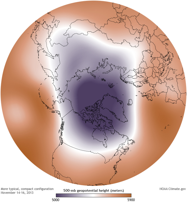
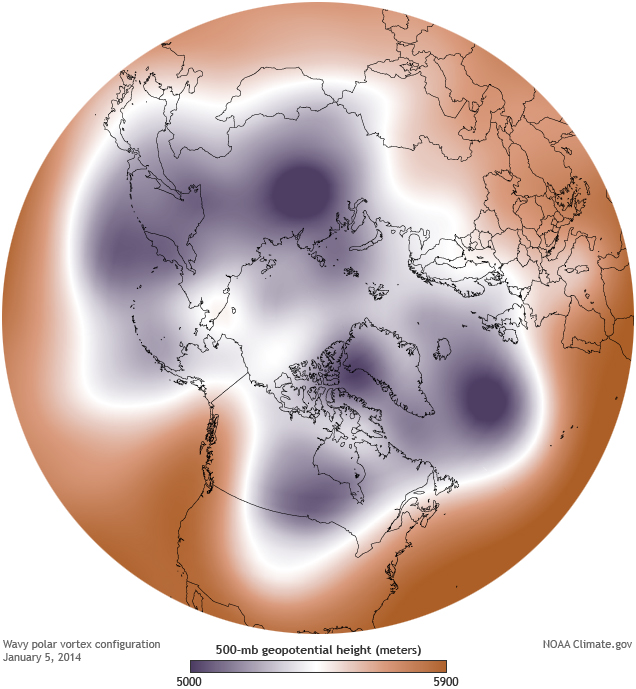
The strength of the polar vortex is directly related to the shape and strength of the polar jet stream, which is the current of strong upper-level winds in the midlatitudes that generally flow from west to east. When the jet stream is “zonal” (west-east oriented) with no large ridges/troughs to perturb it north or south, the polar vortex remains confined near the poles and strengthens since there is so little incoming solar radiation at those high latitudes. When the jet stream is more “amplified” and meanders north and south due to the presence of large ridges and troughs, this cold air is no longer bottled up near the poles and is free to move southward into the midlatitudes.

Credit: climate.gov

Credit: climate.gov
It might seem counter-intuitive that we get our coldest temperatures in the mid-latitudes when the polar vortex is in a “weak” configuration, but the polar vortex needs to weaken in order for it to drift southward in the first place. I’m no polar vortex expert, but it seems intuitively like the most intense arctic outbreaks would occur when a persistent zonal jet stream suddenly buckles due to a ridge forming upstream (to the west), allowing the strong polar vortex that has built up over time to suddenly plunge southward and bring bona-fide arctic air into the mid-latitudes.
Though the temperatures and windchills are undoubtedly brutal, the combination of this frigid air and the relatively warm water temperatures in the Great Lakes has made for some spectacular cloud formations.

Credit: NASA’s TERRA Satellite
The Great Lakes have also seen plenty of “steam fog,” which, like the cloud streets above and associated lake-effect snow, occurs when cold air picks up moisture as it flows over liquid water and becomes saturated in the process. I’ve seen some steam fog over Lake Washington during our cold spells, but nothing like this…
40-foot wall of ice steam on Lake Michigan today outside my window. Chicago is on lockdown today — ain’t nobody going anywhere! #Chiberia #CabinFever pic.twitter.com/qIfcX7SZbm
— Susana leyva (@SusanaLeyva) January 30, 2019
Speaking of cold air in the Pacific Northwest, some models have hinted at the potential for a brief shot of cold, arctic air next week, and some runs have even flirted with the idea of a few snow showers across the region to begin next week. Forecasting snow in the Pacific Northwest is often a crapshoot a day in advance, let alone a week, but it’s encouraging to at least see some of the white stuff in the models. I’ll keep you posted!
Charlie
