Monday, January 25, 2016
1:24 pm
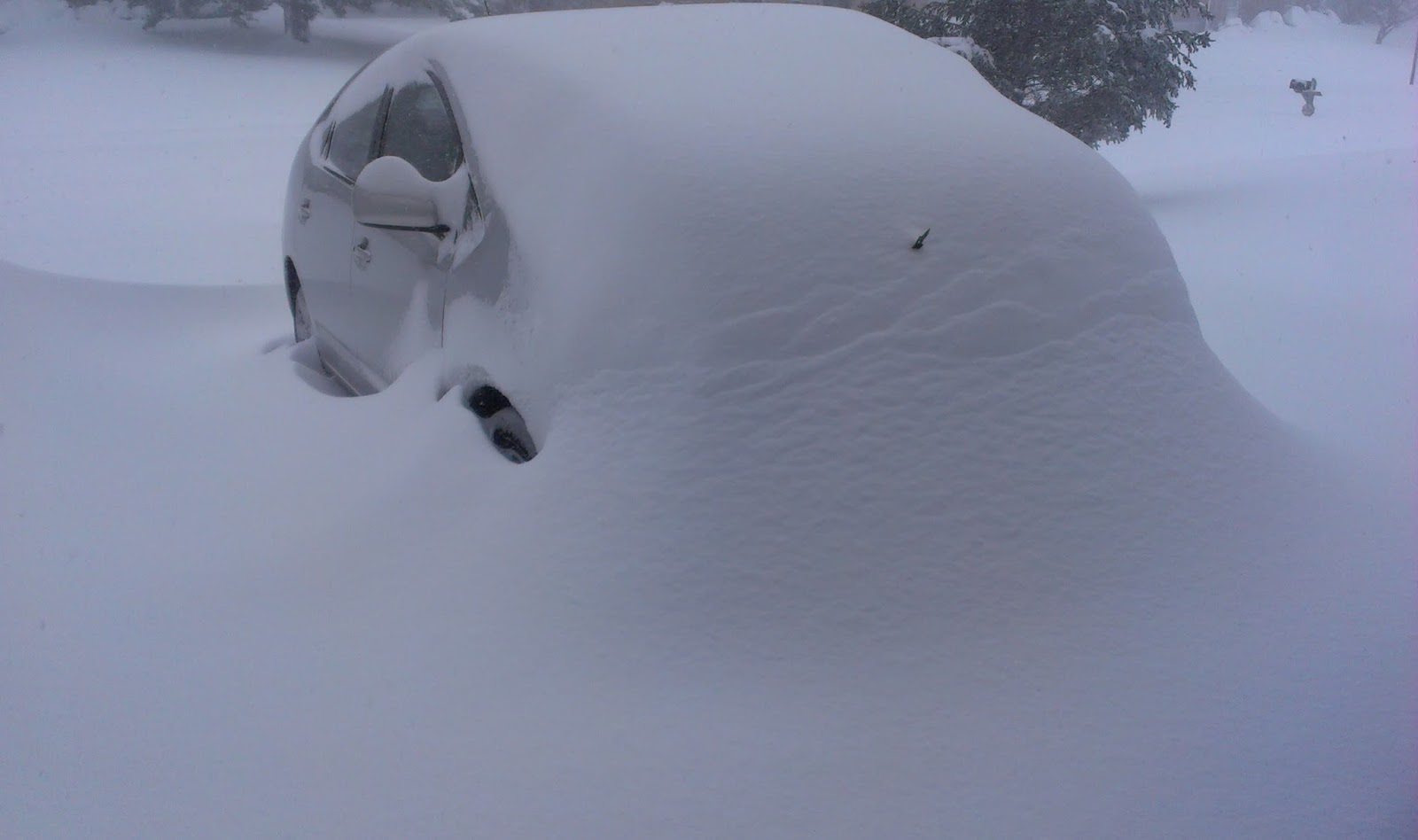 |
| A car submerged in snow. Photo taken 23 January 2016. Credit: Wikimedia User Aude |
Last week in Seattle was pretty stormy, capped off by a very wet Thursday storm that set daily rainfall records throughout Western Washington and major avalanche danger on the Cascades. However, this storm was just child’s play compared to the storm that impacted the eastern third of the country.
Officially known as the “January 2016 United States Blizzard” and unofficially known as “Winter Storm Jonas,” “Winter Storm Anna,” and even “Snowzilla,” this colossal storm has caused at least 42 deaths and up to 3 billion dollars in damage. It directly impacted 85 million people with varying amounts of rain, snow, high winds, and even severe thunderstorms and tornadoes, and had international repercussions. While I’ve seen much stronger blizzards affect remote places like the Bering Sea, I don’t recall ever seeing such an intense and extensive snowstorm affecting so many people here in the lower 48 in my lifetime.
 |
| Snow over the Eastern U.S in the aftermath of the blizzard. Taken 1:30 pm EST on 1/24/2016 Credit: NASA MODIS, Aqua Satellite |
This storm began as a shortwave trough – a small, southward undulation in the jet stream and upper-level flow – over the Pacific Northwest on January 19. The trough deepened and gradually moved to the southeast, becoming a weak area of low pressure over Texas. From there, it began to intensity rapidly as it interacted with an active southern jet stream and abundant moisture from the Gulf of Mexico.
Although that might sound pretty complex to the layperson, this was actually a pretty easy storm to forecast. Unlike small-scale local weather events like Puget Sound Convergence Zones, models generally do a pretty good job with large, powerful extratropical cyclones. Moreover, the precipitation from this storm was falling into sufficiently cold air, so there was no doubt that many areas would see historic snowfall totals. Here in the Pacific Northwest lowlands (and especially west of the Cascades), it is very hard to get both moisture and cold temperatures at the same time, and when we do, our temperatures are often just right on the fringe of freezing and our precipitation is in the form of spotty showers or the aforementioned Puget Sound Convergence Zone rather than widespread rain or snow. The result is, more often than not, a few people win the snow “lottery” and a lot of people come up empty-handed, with some (mainly small, school-going children) even throwing temper-tantrums!
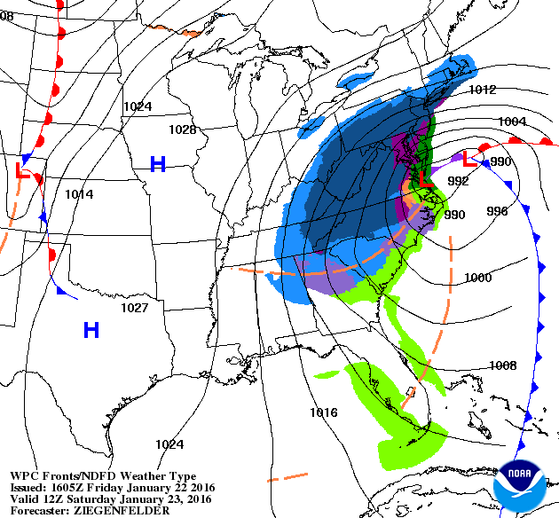 |
| Credit: National Weather Service Weather Prediction Center |
The model chart above shows Friday’s forecast for Saturday. The low takes a nearly perfect trajectory for a major snowstorm and blizzard, skirting just to the east of the coast. With this track, cool winds are pulled down from the north while heavy precipitation falls over the area, creating blizzard conditions.
 |
| Credit: NWS Eastern Region Twitter |
 |
| Credit: NWS Boston Twitter |
The National Weather Service went all-out with their snow forecasts for this storm, and for the most part, they were right. The heaviest snowfall was a little bit further northward and eastward than forecast, meaning that remote settlements like Philadelphia and New York City got higher snow totals than forecast. Central Park had 26.8 inches, a smidge below their all-time record of 26.9 inches, and Philadelphia picked up 22.4 inches. Washington D.C. was forecast to get hammered, and they did, with Dulles airport picking up 29.3 inches.
 |
| Credit: NWS Boston Twitter |
There were also some pretty intense gusts from this storm. Gusts over 40 were common, with many areas having gusts over 50. These wind gusts would be impressive and even dangerous over the Puget Sound lowlands (our large trees greatly amplify the damage here), but when you combine these gusts with snowfall totals of over two feet in many places, you get blizzard conditions, and intense blizzard conditions at that. Again, Dulles Airport was hit hardest with a 52 mph gust, with Philadelphia and Central Park not far behind at 49 and 42 mph respectively. Credit to Accuweather for all of these snow and wind statistics.
Things look to calm down for the foreseeable future on the East Coast, with no major storms in sight. In our neck of the woods, our pattern will remain active. If I decide to go to graduate school down the road, I definitely want to consider researching why this El Niño has not lived up to expectations weatherwise throughout much of the country, particularly the Pacific Northwest. The Climate Prediction Center kept saying that we were going to be drier than normal, especially after the New Year. I thought so too. Instead, we are currently over 10 inches ABOVE normal rain-wise at Sea-Tac since October 1st.
If you ever decide you need to keep your ego in check, take up weather forecasting. On a good day, you are close, and on a bad day, you are completely wrong. It’s not a profession for the faint of heart!
– Charlie

