
Hi all! First off, let me apologize profusely for not being more punctual with this blog. I’ve been very busy with work over the weekdays, and this past weekend, I was out tuna fishing some ~40 miles off the Columbia River. We didn’t exactly knock ’em dead… we only caught one tiny 6 pound tuna, but after learning from the Washington Department of Fish and Wildlife that we were the only people in the port (including 5 charters) that caught any tuna that day, we were pretty ecstatic. If there’s one thing I know about fishing, luck is not part of the equation, and we were objectively the best tuna fishers in all of Ilwaco. Or, at least that’s what I was telling myself after spending 12 hours running through rough seas (and getting very seasick to boot) and only having a glorified mackerel to show for it.

What does tuna fishing have to do with hurricanes? Not much, other than they both occur in the tropics (tuna obviously migrate northward too) and you have to be crazy to want to experience either one. Now, onto the blog.
The 2018 Atlantic Hurricane Season
When it comes to tropical cyclones, I really haven’t had much to write about this year. Only two “tropical” cyclones have hit the US thus far, and I put “tropical” in quotes because the first to hit us was actually designated as a “subtropical storm,” which, for the sake of brevity, is a hybrid tropical/extratropical storm. Subtropical Storm Alberto made landfall near Laguna Beach, Florida on May 28th, making 2018 the fourth consecutive season to have a tropical or subtropical cyclone form before June 1, which is designated as the official start of the Atlantic hurricane season. Tropical Storm Gordon made landfall near Key Largo, Florida on 9/3 and passed over the Gulf of Mexico, making landfall near the Mississippi/Alabama border on 9/4.

Credit: Wikipedia user
Hurricane Florence History
September is the most active month of the year for tropical cyclones in the Atlantic Basin, and Florence became a tropical storm in the wee hours of September 1st near the Cape Verde Islands. It gradually intensified over the next several days and became a hurricane on September 4th, and unexpectedly developed into a Category 4 hurricane by 2 pm PDT on the 5th.

Credit: NASA’s AQUA Satellite
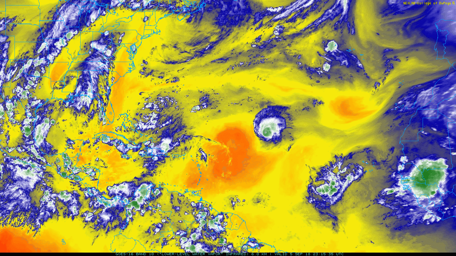
However, this explosive development caused it to veer further northward into a region of stronger wind shear, shredding the cyclone apart. It didn’t help that there was a large mass of hot, dry air on the southern side of the storm either. The loss of storm structure and the intrusion of dry air into caused this hurricane to weaken dramatically to a tropical storm by 5pm EDT Thursday 9/6.

Credit: Levi Cowan, Tropical Tidbits
I figure now is as good a time as any to wax poetic about Levi Cowan’s “Tropical Tidbits” website, which is a fantastic source for all types of weather models, satellite imagery, yearly analogues, you name it. True to its name, Tropical Tidbits is a great source for tropical cyclone forecasts and analysis, and Levi even puts out video briefings for tropical cyclones when he is able. What Levi has done here is nothing short of remarkable and we are all indebted to him for creating such a wonderful and free site. Check it out at www.tropicaltidbits.com and follow Levi on twitter at @TropicalTidbits.
The GOES-16 water vapor satellite imagery below from the College of Dupage shows how dramatically Florence weakened from a major hurricane to a tropical storm over a 24.5-hour loop spanning 7:30 pm 9/5 to 8 pm 9/6.
But on Saturday 9/8, Florence entered more favorable environmental conditions with more moisture and less wind shear, and by 11 am EDT 9/9, she restrengthened to a Category 1 hurricane. Florence continued to intensify as she passed over sea-surface temperatures in the mid 80s and rapidly strengthened overnight Sunday and into Monday 9/10, reaching Category 3 status around 11 am EDT Monday morning and regaining Category 4 status Monday night with 1-minute sustained winds of 140 mph. Though an eyewall replacement cycle weakened the storm slightly earlier today (Tuesday), the storm has resumed strengthening, and the most recent Hurricane Hunter reconnaissance mission reported sustained winds of 140 mph once again.
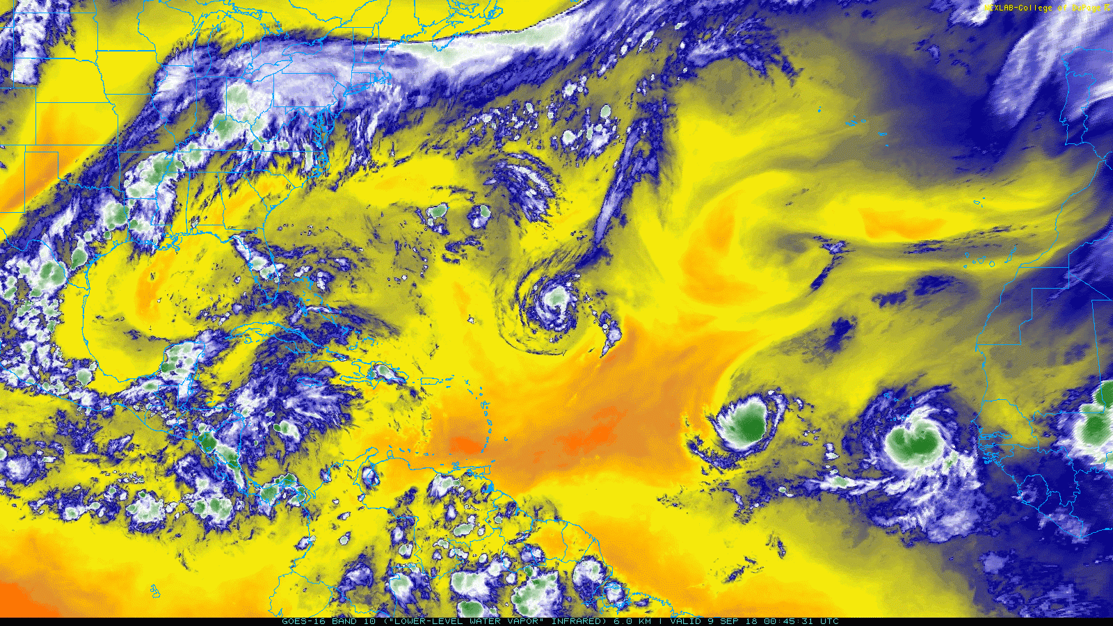
The satellite loop below goes from 8:45 pm EDT Saturday 9/8 to 10:45 pm EDT Tuesday 9/11 and has a coarser time step to reduce the file size. Notice how quickly Florence has restrengthened. Also, you can see Hurricane Helene just west of the Cape Verde Islands beginning to curve northward and Tropical Storm Isaac to Helene’s west tracking due west towards the Caribbean. Thankfully, Isaac is expected to remain a tropical storm as it moves east and makes landfall over the Lesser Antilles on Thursday.
Hurricane Florence Current Conditions and Forecast:
As of 11 pm EDT (AST – Atlantic Standard Time, is the same as Eastern Time), Hurricane Florence was a Category 4 hurricane with maximum one-minute, 10-meter sustained winds of 140 mph, and it is moving to the NW at 17 mph. This is a fairly quick clip for a tropical cyclone, particularly considering that it has not yet felt the tug of the prevailing westerlies that dominate the global atmospheric circulation further north.

The current GOES-16 satellite image from Tropical Tidbits shows new convection occurring along the western and southern portions of the eyewall, signaling that the storm is further intensifying. However, you can see that the southwestern quadrant of the storm outside of the eyewall is much weaker than the northeastern part, and this is due to wind shear from southerly flow aloft over this region. However, this southerly flow aloft – and the resultant wind shear – is expected to decrease as Florence continues its trek northwestward towards the East Coast, and this should allow the storm to regain a more symmetrical appearance and further strengthen over the next several days.

Credit: Levi Cowan, Tropical Tidbits
Most models have Florence peaking as a high-end Category 4 storm as it continues to approach the coast, but models differ greatly on the track and resultant intensity once it actually comes close to landfall. The path of hurricanes is primarily determined by the locations of upper-level highs/lows in the atmosphere and the resultant wind fields that they produce. Florence is expected to move between two upper-level highs – one offshore near Bermuda, and another over the Continental US, and because wind circulates clockwise around areas of high pressure, the upper-level high off Bermuda will try and pull Florence northward while the one over the Eastern US will try and push it southward.

Models have had a lot of trouble modeling the strength of these conflicting air streams, and, by association the track and strength of Florence. However, recent runs paint a dire scenario, with Florence maintaining major hurricane status as it approaches the Carolina Coast and slowing down significantly as it moves onshore, bringing to the region a prolonged period of life-threatening storm surge, extremely strong winds, and perhaps worst of all, catastrophic flooding.
Summary

Hurricane Florence is now an extremely powerful Category 4 cyclone and appears to be strengthening further on satellite, and many models have it maintaining major hurricane status as it makes landfall somewhere along the North Carolina coast on Thursday. As a result, a life-threatening storm surge and a prolonged period of hurricane-force winds looks likely for the North and South Carolinian Coasts, with damaging winds extending into Virginia and the rest of the Carolinas. But the biggest impact from Florence may be catastrophic flash flooding from extremely heavy and prolonged rainfall, as Florence is expected to slow significantly as it approaches the coast or perhaps even stall just offshore.
On that note, it’s wayyyy past my bedtime, so I’m gonna call it a night. I’ll make a sincere effort to keep you updated on Florence, if only with brief posts.
Thanks for reading,
Charlie


4 Comments
Loved your post Charlie! I have been following Florence updates very frequently the past week. Looks like up here in central MD we will get the most significant effects early next week from heavy rain remnants. Path is really up in the air (literally) after it comes ashore on Friday. Love the tropicaltidbits website, I checked it out and registered it through word press. Keep on blogging whenever and wherever you can! Busy times!! Kevin
Thanks Kevin! Yeah, the models are really having trouble with the track of the storm, as slight differences in the strength of the high pressure systems over Bermuda and the SE US have huge impacts on what path the storm will take.
Tropical Tidbits is an absolutely incredible site and Levi is a great guy as well, he was one of the people I first contacted when undertaking my weather model chart project and he helped me get started. My models are only a shadow of his of course… I believe he has the best weather model site in the world. All he needs is the ECMWF!!! 🙂
Congratulations on your new job! Still welcome for Thanksgiving, or any other time, of course!
Thank you Holly! Fortunately/unfortunately, I’ll no longer be working Thanksgivings, so while I’m excited to be able to spend some time with my folks I’ll definitely miss having them with you guys. Tell Isaac to ping me when he’s in town, I’d love to come up and visit!!!