
Hurricane Florence is currently just offshore the North Carolina coast, and North Carolina is absolutely getting hammered as she slowly trudges onshore. As you would expect, the coast has been the hardest hit thus far and has been ravaged by life-threatening storm surge, hurricane-force winds, and multiple flash flood warnings, but gusty winds are occurring throughout the eastern half of the state, and it is only a matter of time before areas further inland see flash flooding as well.
Take a look at the wind and rain outside the NWS Newport/Morehead City forecast office at 9:30 pm Thursday 9/13 evening, and keep in mind that the center of the storm was still at least 50 miles away at this time. This is an absolutely massive storm.
Outside the NWS Newport/Morehead City at 930 pm. pic.twitter.com/tErYVLRYQd
— NWS Newport/Morehead (@NWSMoreheadCity) September 14, 2018
A note on the Saffir-Simpson Scale:
Believe it or not, Florence is only a Category 1 hurricane this morning. If you recall, forecasts a couple days ago had Florence making landfall as a major hurricane (Category 3 or greater). So based on Florence’s Saffir-Simpson rating alone, one might get the impression that this storm is significantly weaker and less dangerous than initially feared. However, nothing could be farther than the truth.
No offense to Misters Saffir and Simpson, but I find the Saffir-Simpson scale to be oversimplistic at best and highly misleading at worst. The scale rates hurricanes on one factor alone: wind speed. But there are so many more things that go into making a hurricane destructive than just its wind speed, and one of the most important is the storm’s size. For a given pressure, a larger storm will have weaker maximum wind speeds, as pressure gradients will be less intense. But while this means wind speeds will be weaker in the storm’s eyewall, it also means that hurricane-force winds will be far more expansive.
In addition to the storm having a larger swath of wind damage, the broader wind field allows a much higher storm surge to build up. Hurricanes Ike, Sandy, and Katrina, the only hurricanes with more than 100 US deaths in the 21st century (with the exception of catastrophic Category 4 (at landfall) Maria in Puerto Rico last year), were only a Category 2, 1, and 3 at landfall. However, they were all extremely large cyclones with expansive wind fields and massive storm surges, and that made them more deadly than compact, quick-moving storms such as high-end Category 4 Charley (2004) or even Hurricane Andrew in 1992, a devastating Category 5 cyclone that directly hit Homestead, Florida (a suburb of Miami) and lashed the area with 165 mph sustained winds.
Current Conditions:
As previously mentioned, Florence is now an extremely large Category 1 hurricane with maximum sustained wind speeds of 90 mph. However, hurricane-force (74+ mph) winds extend 80 miles from the storm’s center. For comparison, Hurricane Patricia (2015), which set a record with maximum sustained winds in the eyewall reaching a staggering 215 mph, only had a 35-mile radius of hurricane-force winds.
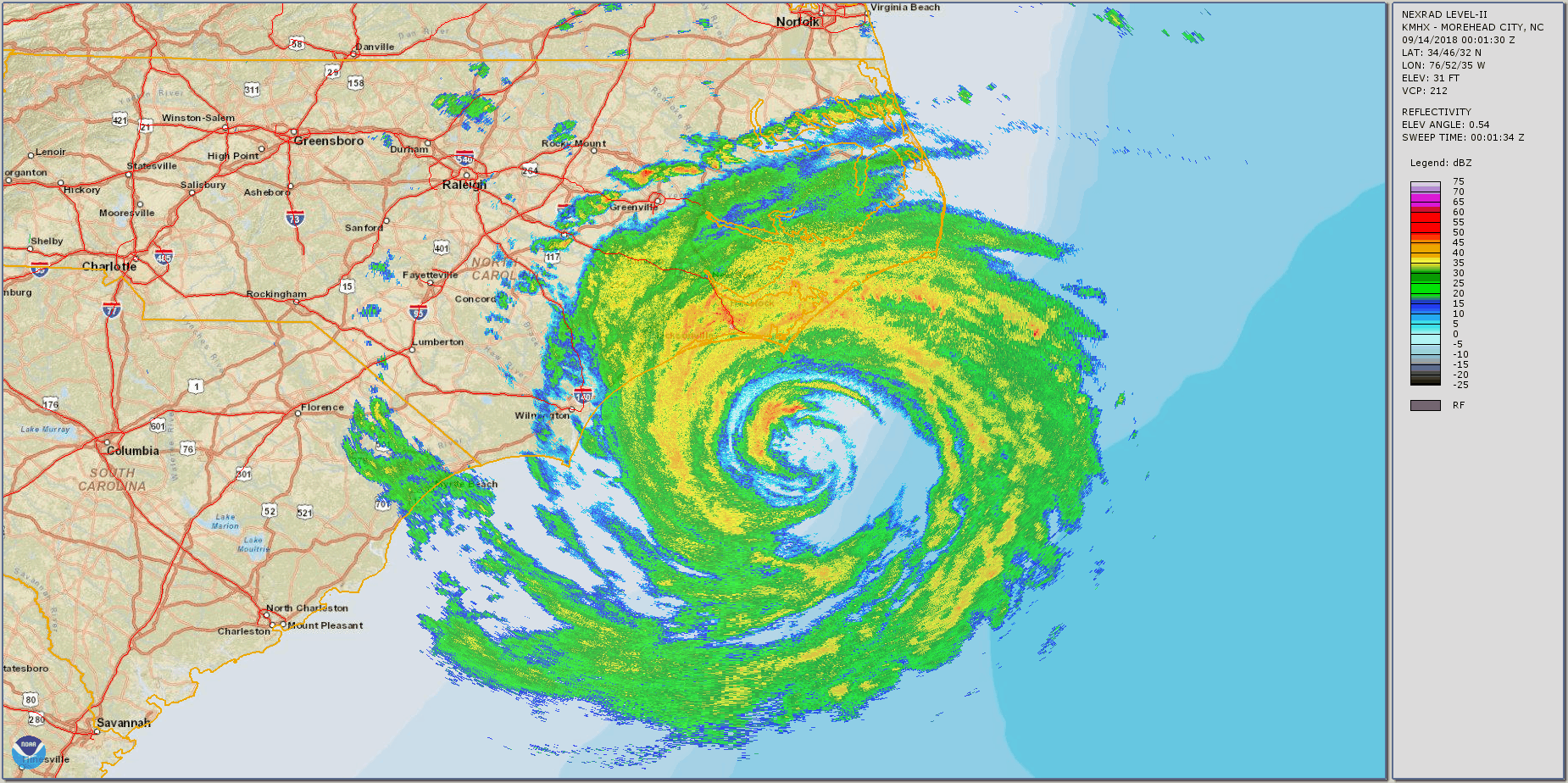
As you can see in the animated radar image above, the storm is quite impressive for a Category 1, but its structure is far from perfect. In particular, notice how only half of the eyewall is present and there is a huge “dry slot” to the north of the eye. This is a common feature with large cyclones such as Florence – the rotating rain bands around the storm are so long that they can intersect and, in the process, “pinch off” the supply of moisture to the eye to some extent. This makes it tough for the hurricane to strengthen any further, and it can weaken their eyewall and therefore the maximum wind speeds. However, it can also further enlarge the hurricane, and as I previously mentioned, hurricane size is often (though not always) a better indicator of damage potential than maximum wind strength.
Florence had a burst of convection late Thursday night, but it has weakened over the past several hours. These bursts of convection occur occasionally and Florence will likely see more bursts before its eye moves inland later this morning. However, it’s worth noting that the north edge of the storm, which has been over land for many hours now, has weakened dramatically over the past few hours. This was bound to happen… hurricanes derive their energy from the evaporation, transport of, and latent heat release of water/water vapor, and once that fuel source (an ocean with 80+ degree temperatures for at least 150 feet down) disappears, the storm will wither away, and will often do so extremely quickly, particularly in the face of terrain.
Finally, let’s take a look at some surface observations. Can you spot the center of circulation? Hint: it’s just a little west of the city where Iron Man 3 was filmed. Click on the image to enlarge.

Credit: NOAA
Forecast:
Florence will make landfall near Wilmington, North Carolina mid-morning today and will continue to slowly trek westward over the next several days. By remaining nearly stationary from now through Saturday evening, Florence is expected to dump incredible amounts of rain over the area that will lead to catastrophic (I’ve been using that word a lot recently, haven’t I?) flash flooding over SE North Carolina and NE South Carolina, with lighter but still very heavy rain elsewhere. I do NOT think Florence will be as destructive as Harvey was, as Harvey was even more immobile and made a direct hit on one of the most flash-flood prone metropolises in the United States. But saying that this storm won’t be as bad as the costliest natural disaster in US history (125 billion dollars, tied with Katrina in 2005 (inflation-adjusted)) doesn’t mean much… Florence will likely cost tens of billions of dollars of damage and the last time I had checked had taken the lives of three citizens (with two of those three being carried out to see by strong rip currents.

Credit: National Hurricane Center
The National Hurricane Center is still calling for a wide swath of 20+ inches of rain over SE North Carolina and extreme NE South Carolina, and isolated spots could pick up more rain from Florence than Portland Int’l Airport experiences in a whole year (average here is 37 inches). As I previously mentioned, we’ve already seen flash flooding, and it will only get worse through tomorrow and beyond.

Credit: National Hurricane Center
By the start of the workweek, the main flooding threat from this storm will be over, as it will be running out of fuel from being over land for so long and will begin heading northeastward as it becomes entrained in the westerlies. But until then, expect extremely heavy rain from Virginia to South Carolina, with the heaviest precipitation centered around Wilmington, North Carolina.
I likely will not be able to blog tomorrow, as I have a gig with my funk band Circular Reasoning the evening, but I’ll see if I can post a quick Facebook update at www.facebook.com/CharlieWxTogether. If you aren’t doing anything tomorrow night (or are doing something, but you’d like to get out of it), come on down to Pono Ranch in Ballard at 8 pm to catch us play! We’d love to see you there, and I’d be happy to talk your head off about Hurricane Florence.
Thanks for reading, and have a great Friday!
Charlie

