Freezing rain is finally over for most of Western Washington. I went out for a walk around Sandpoint Way earlier this evening, and though temperatures were above freezing and the roads were bare and wet, the sidewalks were still a slippery, icy mess. Reports ranged from around 1/8″ of an inch of ice near Bothell […]
Tuesday Snow Update
Quick forecast update. The storm tracked slightly further north than modeled, meaning that mild southerlies (and rain) extended to the King/Snohomish County line instead of staying south of Seattle. The Everett area saw 1-3 inches overnight, depending on elevation, and totals increased northward from there. Whatcom County got clobbered, with reports of over a foot […]
Arctic Outbreak and Lowland Snow Expected This Week For Western Washington
I’ve always said that there are far more snow days forecast for the Pacific Northwest than appear in reality. There are a few reasons for this. The first is that there are multiple weather models, running multiple times a day, that show nearly every possible weather solution under the sun over the course of the […]
A Very Tricky Snow Forecast Today, More Snow Possible Later This Week
Snow is falling over Western Washington and parts of NW Oregon this morning. I’ve been riding the train down from Seattle to Portland and saw close to an inch in the higher elevations near Centralia. I’m now in Kelso and everything has switched to a cold rain, with no snow accumulation to be found. This […]
Lowland Snow Tonight? It’s Possible For SW Washington and NW Oregon
Yes – the rumors are true. There is a chance of lowland snow tonight into Monday morning for Southwest Washington and Northwest Oregon. Some spots over Washington have already seen some snow showers this morning, but the main threat – and the focus of this blog – will be the snow potential Sunday night/Monday morning […]
A Review of the December 2021 Arctic Blast and January 2022 Snow/Flooding
On Friday, Seattle was cut off from the north, the south, and the east due to flooding from the Chehalis River inundating I-5, extreme amounts of snow in the Washington passes, and all roads out of Vancouver BC being closed due to heavy snowfall. None of these individual events are unprecedented – the Chehalis spilled […]
Quick Arctic Blast/Snow Update
Running out the door to head to my energy trading shift, but thought I’d post a quick update regarding the historic arctic blast and our accompanying lowland snow chances before then. Hope to have more tomorrow when there’s a bit more time! Arctic blast: Our extended/extremely strong arctic blast is still on tap, and […]
Brutal Cold To End 2021, White Christmas Possible
The Pacific Northwest has seen tons of mountain snow over the past 10 days. Since December 9, Snoqualmie Pass has seen approximately 8 feet of snow, and all of the major Cascade ski resorts, from Mt. Baker in the North Cascades to Mt. Bachelor in Central Oregon, opened for limited operations last week. I haven’t […]
Record-Setting Tornado Outbreak Devastates South and Midwest
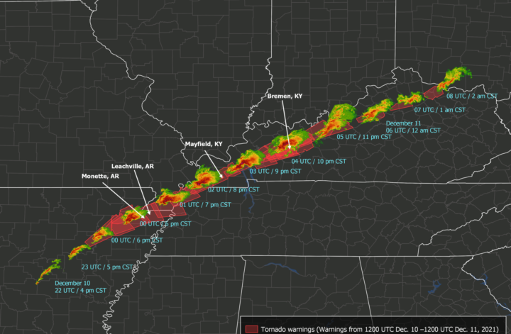
Last night, a rare, catastrophic tornado outbreak occurred over portions of the Southern and Midwestern US. As of Saturday afternoon, 34 people were confirmed dead, with an estimated 75-100 deaths across Missouri, Illinois, Tennessee, and Kentucky and potentially 50-70 deaths in Mayfield, Kentucky alone. Most deaths were due to a series of tornadoes – or […]
Major Snowstorm and Icestorm Increasingly Likely for Western Washington and NW Oregon
It now appears likely that Western Washington and NW Oregon will experience a series of significant winter storms from midday Thursday through Saturday evening, bringing snow, sleet, freezing rain, extremely strong east winds, and a prolonged period of subfreezing temperatures. I’ve been dying to write this post – I’ve been absolutely swamped the past several […]


